Bantay geodata
Bantay (Cordillera) is a populated place; located in Philippines in Asia/Manila (GMT+8) time zone. With population of 2,838 people, there are 2724 cities with bigger population in this country. Compared to other cities in Philippines, 95.8% of cities are located further ↓South; 83.5% of cities are located further →East and 88.1% of cities have lower elevation than Bantay. Note1


Bantay GPS coordinates[2]
17° 26' 16.548" North, 120° 45' 27.9" East
| Map corner | latitude | longitude |
|---|---|---|
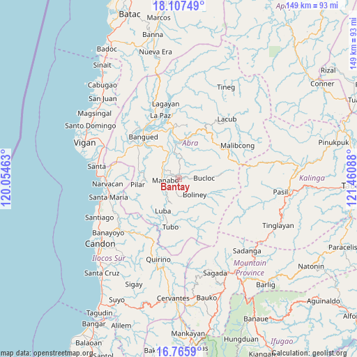
| Upper-left | 18.10749°, | 120.05463° |
| Center: | 17.43793°, | 120.75775° |
| Lower-right: | 16.7659°, | 121.46088° |
| Map W x H: | 149.2×149.2 km | = 92.7×92.7mi |
| max Lat: | 20.78733° ⇑4.2% North |
| Bantay: | 17.43793° |
| min Lat: | ⇓95.8% South 4.65442° |
| min Long | Bantay | max Long |
| 117.04868° | 120.75775° | 126.58417° |
| W 16.5%⇐ | ⇒83.5% E |
Elevation
Elevation of Bantay is 183 m = 600 ft, and this is 95.1 m = 312 ft above average elevation for this country.
| Max E: |
2262 m = 7421 ft | 11.9% |
| Bantay | 183 m 600 ft | |
| Avg. | 87.9 m = 288 ft | |
Min E: |
-2 m = -7 ft | 88.1% |
See also: Philippines elevation on elevation.city.
Geographical zone
Bantay is located in North Torrid zone (between Equator and Tropic of Cancer). Distance of this Northern Tropic circle is 667 km =414.5 mi to North.| Distance of | km | miles | from Bantay |
|---|---|---|---|
| North Pole | 8068.1 | 5013.3 | to North |
| Arctic Circle | 5462.3 | 3394.1 | to North |
| Tropic Cancer | 667 | 414.5 | to North |
| Equator | 1938.9 | 1204.8 | to South |


Nearby cities:
15 places around Bantay: (largest is in red/bold)
• Angad
21.5 km =13.4 mi,  319°
319°
• Bangued
22.8 km =14.2 mi,  326°
326°
• Boliney
4.2 km =2.6 mi,  143°
143°
• Bucay
12.1 km =7.5 mi,  340°
340°
• Bucloc
10.7 km =6.6 mi,  88°
88°
• Daguioman
16.7 km =10.4 mi, 85°
• Lagangilang
19.5 km =12.1 mi,  353°
353°
• Luba
14.9 km =9.3 mi,  206°
206°
• Manabo
5.6 km =3.5 mi,  264°
264°
• Peñarrubia
18 km =11.2 mi, 321°
• Pilar
17.4 km =10.8 mi, 262°
• San Isidro
16.6 km =10.3 mi,  280°
280°
• San Ramon
6 km =3.7 mi,  242°
242°
• Tubo
19.2 km =11.9 mi,  187°
187°
• Villaviciosa
14 km =8.7 mi,  269°
269°
Sources, notices
• [Note1] Compared only with cities in Philippines existing in our database
• [Src1] Map data: © OpenStreetMap contributors (CC-BY-SA)
• [Src2] Other city data from geonames.org with taken over terms of usage.
• [Src3] Geographical zone / Annual Mean Temperature by Robert A. Rohde @ Wikipedia
