Bucloc geodata
Bucloc (Cordillera) is a seat of a third-order administrative division; located in Philippines in Asia/Manila (GMT+8) time zone. In our database, there are 4166 cities with bigger population. Compared to other cities in Philippines, 95.8% of cities are located further ↓South; 80.8% of cities are located further →East and 93.3% of cities have lower elevation than Bucloc. Note1


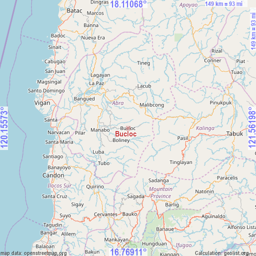
Bucloc GPS coordinates[2]
17° 26' 28.068" North, 120° 51' 31.86" East
| Map corner | latitude | longitude |
|---|---|---|
| Upper-left | 18.11068°, | 120.15573° |
| Center: | 17.44113°, | 120.85885° |
| Lower-right: | 16.76911°, | 121.56198° |
| Map W x H: | 149.2×149.2 km | = 92.7×92.7mi |
| max Lat: | 20.78733° ⇑4.2% North |
| Bucloc: | 17.44113° |
| min Lat: | ⇓95.8% South 4.65442° |
| min Long | Bucloc | max Long |
| 117.04868° | 120.85885° | 126.58417° |
| W 19.2%⇐ | ⇒80.8% E |
Elevation
Elevation of Bucloc is 341 m = 1119 ft, and this is 253.1 m = 830 ft above average elevation for this country.
| Max E: |
2262 m = 7421 ft | 6.7% |
| Bucloc | 341 m 1119 ft | |
| Avg. | 87.9 m = 288 ft | |
Min E: |
-2 m = -7 ft | 93.3% |
See also: Philippines elevation on elevation.city.
Geographical zone
Bucloc is located in North Torrid zone (between Equator and Tropic of Cancer). Distance of this Northern Tropic circle is 666.6 km =414.2 mi to North.| Distance of | km | miles | from Bucloc |
|---|---|---|---|
| North Pole | 8067.8 | 5013.1 | to North |
| Arctic Circle | 5461.9 | 3393.9 | to North |
| Tropic Cancer | 666.6 | 414.2 | to North |
| Equator | 1939.3 | 1205 | to South |


Nearby cities:
15 places around Bucloc: (largest is in red/bold)
• Bantay
10.7 km =6.6 mi,  268°
268°
• Boliney
9 km =5.6 mi,  245°
245°
• Bucay
18.5 km =11.5 mi,  306°
306°
• Daguioman
6.1 km =3.8 mi,  79°
79°
• Dolores
27.9 km =17.3 mi,  325°
325°
• Lagangilang
23.1 km =14.4 mi, 325°
• Licuan
19.3 km =12 mi,  14°
14°
• Luba
22.2 km =13.8 mi,  231°
231°
• Manabo
16.3 km =10.1 mi, 266°
• Peñarrubia
25.9 km =16.1 mi,  302°
302°
• Pilar
28.1 km =17.5 mi,  264°
264°
• San Isidro
27.2 km =16.9 mi,  275°
275°
• San Ramon
16.3 km =10.1 mi, 259°
• Tubo
23.4 km =14.5 mi,  214°
214°
• Villaviciosa
24.7 km =15.3 mi, 269°
Sources, notices
• [Note1] Compared only with cities in Philippines existing in our database
• [Src1] Map data: © OpenStreetMap contributors (CC-BY-SA)
• [Src2] Other city data from geonames.org with taken over terms of usage.
• [Src3] Geographical zone / Annual Mean Temperature by Robert A. Rohde @ Wikipedia
