Lope de Vega geodata
Lope de Vega (Eastern Visayas) is a populated place; located in Philippines in Asia/Manila (GMT+8) time zone. With population of 2,532 people, there are 3241 cities with bigger population in this country. Compared to other cities in Philippines, 53.3% of cities are located further ↓South; 81.2% of cities are located further ←West and 52.3% of cities have lower elevation than Lope de Vega. Note1
Administrative division(s):
- Level 1: Eastern Visayas
- Level 2: Province of Northern Samar
- Level 3: Lope De Vega


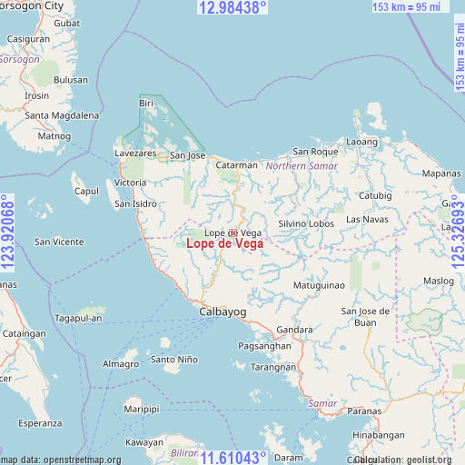
Lope de Vega GPS coordinates[2]
12° 17' 53.88" North, 124° 37' 25.68" East
| Map corner | latitude | longitude |
|---|---|---|
| Upper-left | 12.98438°, | 123.92068° |
| Center: | 12.2983°, | 124.6238° |
| Lower-right: | 11.61043°, | 125.32693° |
| Map W x H: | 152.8×152.8 km | = 94.9×94.9mi |
| max Lat: | 20.78733° ⇑46.7% North |
| Lope de Vega: | 12.2983° |
| min Lat: | ⇓53.3% South 4.65442° |
| min Long | Lope de Vega | max Long |
| 117.04868° | 124.6238° | 126.58417° |
| W 81.2%⇐ | ⇒18.8% E |
Elevation
Elevation of Lope de Vega is 25 m = 82 ft, and this is 62.9 m = 206 ft below average elevation for this country.
| Max E: |
2262 m = 7421 ft | 47.7% |
| Avg. | 87.9 m = 288 ft | |
| Lope de Vega | 25 m = 82 ft | |
Min E: |
-2 m = -7 ft | 52.3% |
See also: Philippines elevation on elevation.city.
Geographical zone
Lope de Vega is located in North Torrid zone (between Equator and Tropic of Cancer). Distance of this Northern Tropic circle is 1238.5 km =769.6 mi to North.| Distance of | km | miles | from Lope de Vega |
|---|---|---|---|
| North Pole | 8639.6 | 5368.4 | to North |
| Arctic Circle | 6033.7 | 3749.2 | to North |
| Tropic Cancer | 1238.5 | 769.6 | to North |
| Equator | 1367.4 | 849.7 | to South |


Nearby cities:
15 places around Lope de Vega: (largest is in red/bold)
• Bobon
26 km =16.2 mi,  345°
345°
• Calbayog City
25.9 km =16.1 mi,  186°
186°
• Catarman
22.4 km =13.9 mi,  3°
3°
• Cervantes
8.7 km =5.4 mi,  26°
26°
• Makiwalo
25.2 km =15.7 mi,  20°
20°
• Malaga
27.9 km =17.3 mi,  255°
255°
• Malajog
26.2 km =16.3 mi,  216°
216°
• Mondragon
27.9 km =17.3 mi, 29°
• Piña
27 km =16.8 mi,  243°
243°
• Polañge
11 km =6.8 mi, 4°
• Sabang
26.4 km =16.4 mi,  199°
199°
• San Joaquin
25.6 km =15.9 mi, 235°
• San Policarpio
26.2 km =16.3 mi, 193°
• Silvino Lobos
22.8 km =14.2 mi,  89°
89°
• Tinambacan
26.2 km =16.3 mi,  210°
210°
Sources, notices
• [Note1] Compared only with cities in Philippines existing in our database
• [Src1] Map data: © OpenStreetMap contributors (CC-BY-SA)
• [Src2] Other city data from geonames.org with taken over terms of usage.
• [Src3] Geographical zone / Annual Mean Temperature by Robert A. Rohde @ Wikipedia
