Catarman geodata
Catarman (Eastern Visayas) is a seat of a third-order administrative division; located in Philippines in Asia/Manila (GMT+8) time zone. With population of 47,449 people, there are 185 cities with bigger population in this country. Compared to other cities in Philippines, 54.8% of cities are located further ↓South; 81.4% of cities are located further ←West and 73.2% of cities have higher elevation than Catarman. Note1
Administrative division(s):
- Level 1: Eastern Visayas
- Level 2: Province of Northern Samar
- Level 3: Catarman


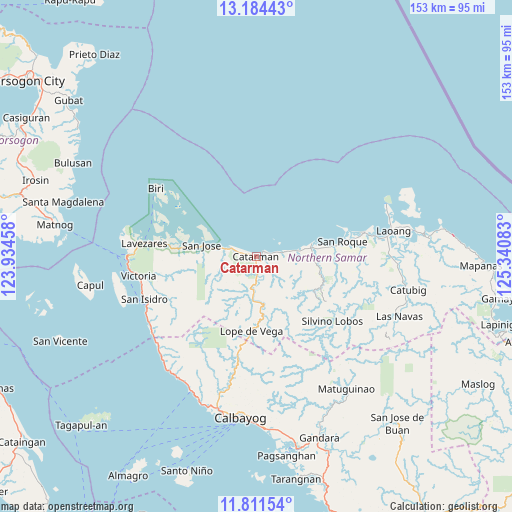
Catarman GPS coordinates[2]
12° 29' 56.04" North, 124° 38' 15.72" East
| Map corner | latitude | longitude |
|---|---|---|
| Upper-left | 13.18443°, | 123.93458° |
| Center: | 12.4989°, | 124.6377° |
| Lower-right: | 11.81154°, | 125.34083° |
| Map W x H: | 152.7×152.7 km | = 94.9×94.9mi |
| max Lat: | 20.78733° ⇑45.2% North |
| Catarman: | 12.4989° |
| min Lat: | ⇓54.8% South 4.65442° |
| min Long | Catarman | max Long |
| 117.04868° | 124.6377° | 126.58417° |
| W 81.4%⇐ | ⇒18.6% E |
Elevation
Elevation of Catarman is 11 m = 36 ft, and this is 76.9 m = 252 ft below average elevation for this country.
| Max E: |
2262 m = 7421 ft | 73.2% |
| Avg. | 87.9 m = 288 ft | |
| Catarman | 11 m = 36 ft | |
Min E: |
-2 m = -7 ft | 26.8% |
See also: Catarman elevation on elevation.city.
Geographical zone
Catarman is located in North Torrid zone (between Equator and Tropic of Cancer). Distance of this Northern Tropic circle is 1216.2 km =755.7 mi to North.| Distance of | km | miles | from Catarman |
|---|---|---|---|
| North Pole | 8617.3 | 5354.5 | to North |
| Arctic Circle | 6011.4 | 3735.3 | to North |
| Tropic Cancer | 1216.2 | 755.7 | to North |
| Equator | 1389.7 | 863.5 | to South |


Nearby cities:
15 places around Catarman: (largest is in red/bold)
• Bantayan
20.9 km =13 mi,  82°
82°
• Bobon
8.5 km =5.3 mi,  289°
289°
• Bugko
17.3 km =10.7 mi, 76°
• Cervantes
14.7 km =9.1 mi,  170°
170°
• Lavezares
33.6 km =20.9 mi,  276°
276°
• Lope de Vega
22.4 km =13.9 mi,  183°
183°
• Makiwalo
7.5 km =4.7 mi, 80°
• Mondragon
12.6 km =7.8 mi, 81°
• Nenita
18.1 km =11.2 mi,  92°
92°
• Pambujan
32.3 km =20.1 mi, 77°
• Polañge
11.4 km =7.1 mi, 183°
• Rosario
23.2 km =14.4 mi, 276°
• San Jose
16.7 km =10.4 mi, 281°
• San Roque
25.1 km =15.6 mi, 81°
• Silvino Lobos
30.7 km =19.1 mi,  136°
136°
Sources, notices
• [Note1] Compared only with cities in Philippines existing in our database
• [Src1] Map data: © OpenStreetMap contributors (CC-BY-SA)
• [Src2] Other city data from geonames.org with taken over terms of usage.
• [Src3] Geographical zone / Annual Mean Temperature by Robert A. Rohde @ Wikipedia
