Linamon geodata
Linamon (Northern Mindanao) is a populated place; located in Philippines in Asia/Manila (GMT+8) time zone. With population of 6,848 people, there are 913 cities with bigger population in this country. Compared to other cities in Philippines, 80.9% of cities are located further ↑North; 73.5% of cities are located further ←West and 89.7% of cities have higher elevation than Linamon. Note1
Administrative division(s):
- Level 1: Northern Mindanao
- Level 2: Province of Lanao del Norte
- Level 3: Iligan City


Linamon GPS coordinates[2]
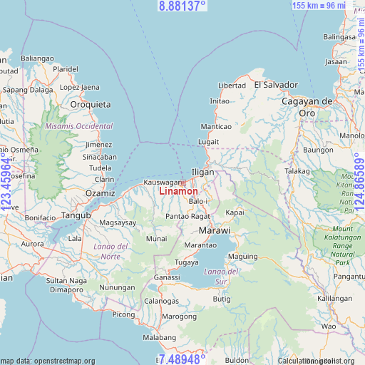
8° 11' 9.708" North, 124° 9' 45.936" East
| Map corner | latitude | longitude |
|---|---|---|
| Upper-left | 8.88137°, | 123.45964° |
| Center: | 8.18603°, | 124.16276° |
| Lower-right: | 7.48948°, | 124.86589° |
| Map W x H: | 154.8×154.8 km | = 96.2×96.2mi |
| max Lat: | 20.78733° ⇑80.9% North |
| Linamon: | 8.18603° |
| min Lat: | ⇓19.1% South 4.65442° |
| min Long | Linamon | max Long |
| 117.04868° | 124.16276° | 126.58417° |
| W 73.5%⇐ | ⇒26.5% E |
Elevation
Elevation of Linamon is 7 m = 23 ft, and this is 80.9 m = 265 ft below average elevation for this country.
| Max E: |
2262 m = 7421 ft | 89.7% |
| Avg. | 87.9 m = 288 ft | |
| Linamon | 7 m = 23 ft | |
Min E: |
-2 m = -7 ft | 10.3% |
See also: Philippines elevation on elevation.city.
Geographical zone
Linamon is located in North Torrid zone (between Equator and Tropic of Cancer). Distance of Equator is 910.2 km =565.6 mi to South.| Distance of | km | miles | from Linamon |
|---|---|---|---|
| North Pole | 9096.9 | 5652.5 | to North |
| Arctic Circle | 6491 | 4033.3 | to North |
| Tropic Cancer | 1695.7 | 1053.7 | to North |
| Equator | 910.2 | 565.6 | to South |


Nearby cities:
15 places around Linamon: (largest is in red/bold)
• Boroon
1.6 km =1 mi,  102°
102°
• Dimayon
13.3 km =8.3 mi,  186°
186°
• Iligan
10.1 km =6.3 mi,  61°
61°
• Kalanganan
14.7 km =9.1 mi,  141°
141°
• Kauswagan
8.6 km =5.3 mi,  274°
274°
• Kawit
10.6 km =6.6 mi, 270°
• Libertad
10.5 km =6.5 mi,  47°
47°
• Mamungan
9.8 km =6.1 mi, 141°
• Mantampay
6.3 km =3.9 mi,  109°
109°
• Maria Cristina
5 km =3.1 mi,  116°
116°
• Matungao
5.6 km =3.5 mi,  178°
178°
• Nañgka
3.1 km =1.9 mi,  133°
133°
• Pantao-Ragat
11.9 km =7.4 mi,  195°
195°
• Poona-Piagapo
12.5 km =7.8 mi, 203°
• Tacub
6 km =3.7 mi, 271°
Sources, notices
• [Note1] Compared only with cities in Philippines existing in our database
• [Src1] Map data: © OpenStreetMap contributors (CC-BY-SA)
• [Src2] Other city data from geonames.org with taken over terms of usage.
• [Src3] Geographical zone / Annual Mean Temperature by Robert A. Rohde @ Wikipedia
