Iligan geodata
Iligan (Northern Mindanao) is a seat of a third-order administrative division; located in Philippines in Asia/Manila (GMT+8) time zone. With population of 342,618 people, there are 23 cities with bigger population in this country. Compared to other cities in Philippines, 80.5% of cities are located further ↑North; 74.4% of cities are located further ←West and 95.5% of cities have higher elevation than Iligan. Note1
Administrative division(s):
- Level 1: Northern Mindanao
- Level 2: Province of Lanao del Norte
- Level 3: Iligan City


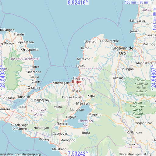
Iligan GPS coordinates[2]
8° 13' 44.04" North, 124° 14' 36.384" East
| Map corner | latitude | longitude |
|---|---|---|
| Upper-left | 8.92416°, | 123.54032° |
| Center: | 8.2289°, | 124.24344° |
| Lower-right: | 7.53242°, | 124.94657° |
| Map W x H: | 154.7×154.8 km | = 96.1×96.2mi |
| max Lat: | 20.78733° ⇑80.5% North |
| Iligan: | 8.2289° |
| min Lat: | ⇓19.5% South 4.65442° |
| min Long | Iligan | max Long |
| 117.04868° | 124.24344° | 126.58417° |
| W 74.4%⇐ | ⇒25.6% E |
Elevation
Elevation of Iligan is 5 m = 16 ft, and this is 82.9 m = 272 ft below average elevation for this country.
| Max E: |
2262 m = 7421 ft | 95.5% |
| Avg. | 87.9 m = 288 ft | |
| Iligan | 5 m = 16 ft | |
Min E: |
-2 m = -7 ft | 4.5% |
See also: Iligan elevation on elevation.city.
Geographical zone
Iligan is located in North Torrid zone (between Equator and Tropic of Cancer). Distance of Equator is 915 km =568.6 mi to South.| Distance of | km | miles | from Iligan |
|---|---|---|---|
| North Pole | 9092.1 | 5649.6 | to North |
| Arctic Circle | 6486.2 | 4030.3 | to North |
| Tropic Cancer | 1691 | 1050.7 | to North |
| Equator | 915 | 568.6 | to South |


Nearby cities:
15 places around Iligan: (largest is in red/bold)
• Biga
14.4 km =8.9 mi,  7°
7°
• Boroon
8.9 km =5.5 mi,  234°
234°
• Buawan
11.8 km =7.3 mi,  33°
33°
• Dalipuga
9.7 km =6 mi, 7°
• Digkilaan
8.5 km =5.3 mi,  73°
73°
• Libertad
2.6 km =1.6 mi,  334°
334°
• Linamon
10.1 km =6.3 mi,  241°
241°
• Lugait
12.6 km =7.8 mi, 7°
• Mamungan
12.7 km =7.9 mi,  192°
192°
• Mantampay
7.5 km =4.7 mi,  203°
203°
• Maria Cristina
8.2 km =5.1 mi,  211°
211°
• Matungao
13.5 km =8.4 mi,  220°
220°
• Nañgka
9.6 km =6 mi, 223°
• Rogongon
9.9 km =6.2 mi,  87°
87°
• Tacub
15.6 km =9.7 mi,  252°
252°
Sources, notices
• [Note1] Compared only with cities in Philippines existing in our database
• [Src1] Map data: © OpenStreetMap contributors (CC-BY-SA)
• [Src2] Other city data from geonames.org with taken over terms of usage.
• [Src3] Geographical zone / Annual Mean Temperature by Robert A. Rohde @ Wikipedia
