Lilio geodata
Lilio (Calabarzon) is a populated place; located in Philippines in Asia/Manila (GMT+8) time zone. With population of 15,246 people, there are 441 cities with bigger population in this country. Compared to other cities in Philippines, 70.9% of cities are located further ↓South; 67.8% of cities are located further →East and 91% of cities have lower elevation than Lilio. Note1


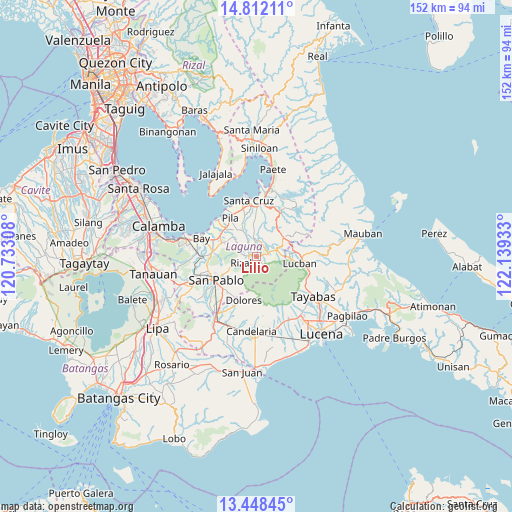
Lilio GPS coordinates[2]
14° 7' 52.68" North, 121° 26' 10.32" East
| Map corner | latitude | longitude |
|---|---|---|
| Upper-left | 14.81211°, | 120.73308° |
| Center: | 14.1313°, | 121.4362° |
| Lower-right: | 13.44845°, | 122.13933° |
| Map W x H: | 151.6×151.6 km | = 94.2×94.2mi |
| max Lat: | 20.78733° ⇑29.1% North |
| Lilio: | 14.1313° |
| min Lat: | ⇓70.9% South 4.65442° |
| min Long | Lilio | max Long |
| 117.04868° | 121.4362° | 126.58417° |
| W 32.2%⇐ | ⇒67.8% E |
Elevation
Elevation of Lilio is 256 m = 840 ft, and this is 168.1 m = 552 ft above average elevation for this country.
| Max E: |
2262 m = 7421 ft | 9% |
| Lilio | 256 m 840 ft | |
| Avg. | 87.9 m = 288 ft | |
Min E: |
-2 m = -7 ft | 91% |
See also: Philippines elevation on elevation.city.
Geographical zone
Lilio is located in North Torrid zone (between Equator and Tropic of Cancer). Distance of this Northern Tropic circle is 1034.7 km =642.9 mi to North.| Distance of | km | miles | from Lilio |
|---|---|---|---|
| North Pole | 8435.8 | 5241.8 | to North |
| Arctic Circle | 5829.9 | 3622.5 | to North |
| Tropic Cancer | 1034.7 | 642.9 | to North |
| Equator | 1571.3 | 976.4 | to South |


Nearby cities:
15 places around Lilio: (largest is in red/bold)
• Calumpang
8.1 km =5 mi,  333°
333°
• Halayhayin
7.1 km =4.4 mi, 334°
• Luisiana
10 km =6.2 mi,  53°
53°
• Magdalena
7.7 km =4.8 mi,  354°
354°
• Majayjay
4.3 km =2.7 mi,  67°
67°
• Nagcarlan
2.2 km =1.4 mi,  284°
284°
• Rizal
5.2 km =3.2 mi,  242°
242°
• San Antonio
10.3 km =6.4 mi,  42°
42°
• San Diego
8.3 km =5.2 mi, 41°
• San Isidro
9.5 km =5.9 mi, 334°
• San Miguel
10.3 km =6.4 mi,  318°
318°
• San Rafael
2.3 km =1.4 mi,  262°
262°
• Santa Catalina
10.2 km =6.3 mi, 263°
• Santo Tomas
9 km =5.6 mi, 49°
• Taytay
3.5 km =2.2 mi, 259°
Sources, notices
• [Note1] Compared only with cities in Philippines existing in our database
• [Src1] Map data: © OpenStreetMap contributors (CC-BY-SA)
• [Src2] Other city data from geonames.org with taken over terms of usage.
• [Src3] Geographical zone / Annual Mean Temperature by Robert A. Rohde @ Wikipedia
