Taytay geodata
Taytay (Calabarzon) is a populated place; located in Philippines in Asia/Manila (GMT+8) time zone. With population of 2,670 people, there are 3000 cities with bigger population in this country. Compared to other cities in Philippines, 70.8% of cities are located further ↓South; 68.5% of cities are located further →East and 90.6% of cities have lower elevation than Taytay. Note1


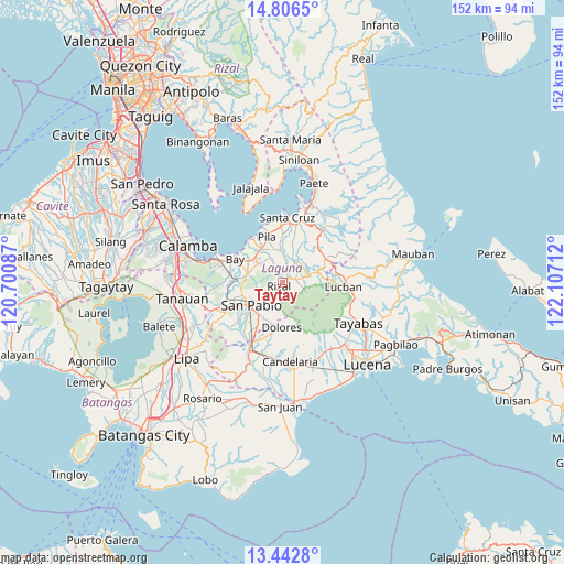
Taytay GPS coordinates[2]
14° 7' 32.412" North, 121° 24' 14.364" East
| Map corner | latitude | longitude |
|---|---|---|
| Upper-left | 14.8065°, | 120.70087° |
| Center: | 14.12567°, | 121.40399° |
| Lower-right: | 13.4428°, | 122.10712° |
| Map W x H: | 151.6×151.6 km | = 94.2×94.2mi |
| max Lat: | 20.78733° ⇑29.2% North |
| Taytay: | 14.12567° |
| min Lat: | ⇓70.8% South 4.65442° |
| min Long | Taytay | max Long |
| 117.04868° | 121.40399° | 126.58417° |
| W 31.5%⇐ | ⇒68.5% E |
Elevation
Elevation of Taytay is 240 m = 787 ft, and this is 152.1 m = 499 ft above average elevation for this country.
| Max E: |
2262 m = 7421 ft | 9.4% |
| Taytay | 240 m 787 ft | |
| Avg. | 87.9 m = 288 ft | |
Min E: |
-2 m = -7 ft | 90.6% |
See also: Philippines elevation on elevation.city.
Geographical zone
Taytay is located in North Torrid zone (between Equator and Tropic of Cancer). Distance of this Northern Tropic circle is 1035.3 km =643.3 mi to North.| Distance of | km | miles | from Taytay |
|---|---|---|---|
| North Pole | 8436.4 | 5242.1 | to North |
| Arctic Circle | 5830.5 | 3622.9 | to North |
| Tropic Cancer | 1035.3 | 643.3 | to North |
| Equator | 1570.6 | 975.9 | to South |


Nearby cities:
15 places around Taytay: (largest is in red/bold)
• Calauan
9.9 km =6.2 mi,  285°
285°
• Calumpang
7.9 km =4.9 mi,  358°
358°
• Dayap
9.7 km =6 mi,  308°
308°
• Halayhayin
7.1 km =4.4 mi,  3°
3°
• Lilio
3.5 km =2.2 mi,  79°
79°
• Magdalena
8.7 km =5.4 mi,  18°
18°
• Majayjay
7.8 km =4.8 mi,  72°
72°
• Masapang
10.4 km =6.5 mi,  320°
320°
• Nagcarlan
1.8 km =1.1 mi,  48°
48°
• Rizal
2.1 km =1.3 mi,  211°
211°
• San Isidro
9.2 km =5.7 mi, 356°
• San Miguel
9 km =5.6 mi,  338°
338°
• San Rafael
1.2 km =0.7 mi, 75°
• Santa Catalina
6.7 km =4.2 mi,  265°
265°
• Santa Lucia
10.5 km =6.5 mi,  163°
163°
Sources, notices
• [Note1] Compared only with cities in Philippines existing in our database
• [Src1] Map data: © OpenStreetMap contributors (CC-BY-SA)
• [Src2] Other city data from geonames.org with taken over terms of usage.
• [Src3] Geographical zone / Annual Mean Temperature by Robert A. Rohde @ Wikipedia
