Majayjay geodata
Majayjay (Calabarzon) is a seat of a third-order administrative division; located in Philippines in Asia/Manila (GMT+8) time zone. With population of 11,412 people, there are 541 cities with bigger population in this country. Compared to other cities in Philippines, 71.1% of cities are located further ↓South; 67% of cities are located further →East and 91.8% of cities have lower elevation than Majayjay. Note1


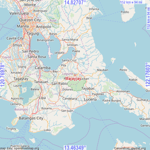
Majayjay GPS coordinates[2]
14° 8' 46.68" North, 121° 28' 22.44" East
| Map corner | latitude | longitude |
|---|---|---|
| Upper-left | 14.82707°, | 120.76978° |
| Center: | 14.1463°, | 121.4729° |
| Lower-right: | 13.46349°, | 122.17603° |
| Map W x H: | 151.6×151.6 km | = 94.2×94.2mi |
| max Lat: | 20.78733° ⇑28.9% North |
| Majayjay: | 14.1463° |
| min Lat: | ⇓71.1% South 4.65442° |
| min Long | Majayjay | max Long |
| 117.04868° | 121.4729° | 126.58417° |
| W 33%⇐ | ⇒67% E |
Elevation
Elevation of Majayjay is 281 m = 922 ft, and this is 193.1 m = 634 ft above average elevation for this country.
| Max E: |
2262 m = 7421 ft | 8.2% |
| Majayjay | 281 m 922 ft | |
| Avg. | 87.9 m = 288 ft | |
Min E: |
-2 m = -7 ft | 91.8% |
See also: Philippines elevation on elevation.city.
Geographical zone
Majayjay is located in North Torrid zone (between Equator and Tropic of Cancer). Distance of this Northern Tropic circle is 1033 km =641.9 mi to North.| Distance of | km | miles | from Majayjay |
|---|---|---|---|
| North Pole | 8434.1 | 5240.7 | to North |
| Arctic Circle | 5828.3 | 3621.5 | to North |
| Tropic Cancer | 1033 | 641.9 | to North |
| Equator | 1572.9 | 977.4 | to South |


Nearby cities:
15 places around Majayjay: (largest is in red/bold)
• Calumpang
9.5 km =5.9 mi,  306°
306°
• Cigaras
10.1 km =6.3 mi,  332°
332°
• Halayhayin
8.5 km =5.3 mi,  304°
304°
• Lilio
4.3 km =2.7 mi,  247°
247°
• Lucban
9.6 km =6 mi,  112°
112°
• Luisiana
5.9 km =3.7 mi,  43°
43°
• Magdalena
7.6 km =4.7 mi,  321°
321°
• Nagcarlan
6.2 km =3.9 mi,  259°
259°
• Rizal
9.5 km =5.9 mi,  244°
244°
• San Antonio
6.6 km =4.1 mi,  26°
26°
• San Diego
4.8 km =3 mi,  18°
18°
• San Isidro
10.6 km =6.6 mi, 310°
• San Rafael
6.6 km =4.1 mi, 252°
• Santo Tomas
5 km =3.1 mi, 35°
• Taytay
7.8 km =4.8 mi, 252°
Sources, notices
• [Note1] Compared only with cities in Philippines existing in our database
• [Src1] Map data: © OpenStreetMap contributors (CC-BY-SA)
• [Src2] Other city data from geonames.org with taken over terms of usage.
• [Src3] Geographical zone / Annual Mean Temperature by Robert A. Rohde @ Wikipedia
