Atabayan geodata
Atabayan (Western Visayas) is a populated place; located in Philippines in Asia/Manila (GMT+8) time zone. With population of 2,362 people, there are 3532 cities with bigger population in this country. Compared to other cities in Philippines, 61.2% of cities are located further ↑North; 55.9% of cities are located further →East and 85.4% of cities have higher elevation than Atabayan. Note1


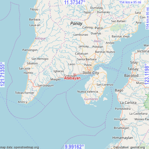
Atabayan GPS coordinates[2]
10° 40' 59.988" North, 122° 25' 0.012" East
| Map corner | latitude | longitude |
|---|---|---|
| Upper-left | 11.37347°, | 121.71355° |
| Center: | 10.68333°, | 122.41667° |
| Lower-right: | 9.99162°, | 123.1198° |
| Map W x H: | 153.6×153.6 km | = 95.4×95.4mi |
| max Lat: | 20.78733° ⇑61.2% North |
| Atabayan: | 10.68333° |
| min Lat: | ⇓38.8% South 4.65442° |
| min Long | Atabayan | max Long |
| 117.04868° | 122.41667° | 126.58417° |
| W 44.1%⇐ | ⇒55.9% E |
Elevation
Elevation of Atabayan is 8 m = 26 ft, and this is 79.9 m = 262 ft below average elevation for this country.
| Max E: |
2262 m = 7421 ft | 85.4% |
| Avg. | 87.9 m = 288 ft | |
| Atabayan | 8 m = 26 ft | |
Min E: |
-2 m = -7 ft | 14.6% |
See also: Philippines elevation on elevation.city.
Geographical zone
Atabayan is located in North Torrid zone (between Equator and Tropic of Cancer). Distance of Equator is 1187.9 km =738.1 mi to South.| Distance of | km | miles | from Atabayan |
|---|---|---|---|
| North Pole | 8819.2 | 5480 | to North |
| Arctic Circle | 6213.3 | 3860.8 | to North |
| Tropic Cancer | 1418 | 881.1 | to North |
| Equator | 1187.9 | 738.1 | to South |


Nearby cities:
15 places around Atabayan: (largest is in red/bold)
• Abilay
10.7 km =6.6 mi,  58°
58°
• Buray
5.9 km =3.7 mi,  52°
52°
• Buyuan
6.6 km =4.1 mi,  257°
257°
• Cagbang
9.2 km =5.7 mi,  78°
78°
• Cordova
5.5 km =3.4 mi,  342°
342°
• Guimbal
10.5 km =6.5 mi, 257°
• Igcocolo
10.7 km =6.6 mi,  273°
273°
• Leon
11.2 km =7 mi, 344°
• Napnapan
3.8 km =2.4 mi,  317°
317°
• Oton
6.3 km =3.9 mi, 80°
• San Miguel
12 km =7.5 mi,  26°
26°
• San Nicolas
8.6 km =5.3 mi,  89°
89°
• Santa Monica
7.1 km =4.4 mi, 34°
• Tigbauan
4.4 km =2.7 mi, 257°
• Trapiche
1.7 km =1.1 mi, 86°
Sources, notices
• [Note1] Compared only with cities in Philippines existing in our database
• [Src1] Map data: © OpenStreetMap contributors (CC-BY-SA)
• [Src2] Other city data from geonames.org with taken over terms of usage.
• [Src3] Geographical zone / Annual Mean Temperature by Robert A. Rohde @ Wikipedia
