Buray geodata
Buray (Western Visayas) is a populated place; located in Philippines in Asia/Manila (GMT+8) time zone. With population of 3,863 people, there are 1802 cities with bigger population in this country. Compared to other cities in Philippines, 60.6% of cities are located further ↑North; 55.5% of cities are located further →East and 65.1% of cities have higher elevation than Buray. Note1


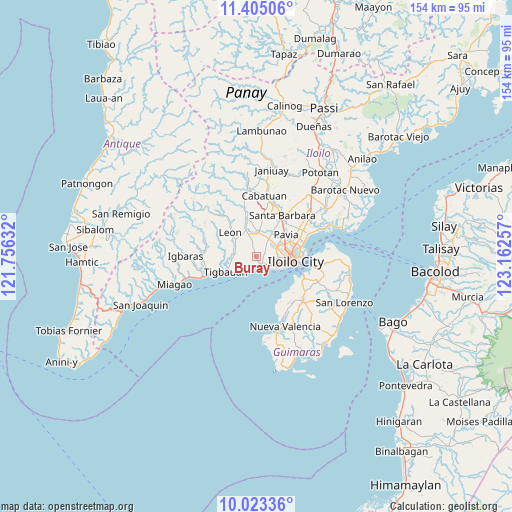
Buray GPS coordinates[2]
10° 42' 54" North, 122° 27' 33.984" East
| Map corner | latitude | longitude |
|---|---|---|
| Upper-left | 11.40506°, | 121.75632° |
| Center: | 10.715°, | 122.45944° |
| Lower-right: | 10.02336°, | 123.16257° |
| Map W x H: | 153.6×153.6 km | = 95.4×95.4mi |
| max Lat: | 20.78733° ⇑60.6% North |
| Buray: | 10.715° |
| min Lat: | ⇓39.4% South 4.65442° |
| min Long | Buray | max Long |
| 117.04868° | 122.45944° | 126.58417° |
| W 44.5%⇐ | ⇒55.5% E |
Elevation
Elevation of Buray is 14 m = 46 ft, and this is 73.9 m = 242 ft below average elevation for this country.
| Max E: |
2262 m = 7421 ft | 65.1% |
| Avg. | 87.9 m = 288 ft | |
| Buray | 14 m = 46 ft | |
Min E: |
-2 m = -7 ft | 34.9% |
See also: Philippines elevation on elevation.city.
Geographical zone
Buray is located in North Torrid zone (between Equator and Tropic of Cancer). Distance of Equator is 1191.4 km =740.3 mi to South.| Distance of | km | miles | from Buray |
|---|---|---|---|
| North Pole | 8815.7 | 5477.8 | to North |
| Arctic Circle | 6209.8 | 3858.6 | to North |
| Tropic Cancer | 1414.5 | 878.9 | to North |
| Equator | 1191.4 | 740.3 | to South |


Nearby cities:
15 places around Buray: (largest is in red/bold)
• Abilay
4.9 km =3 mi,  65°
65°
• Atabayan
5.9 km =3.7 mi,  232°
232°
• Balabag
6.5 km =4 mi,  34°
34°
• Cagbang
4.6 km =2.9 mi,  111°
111°
• Cordova
6.6 km =4.1 mi,  284°
284°
• Jibao-an
8.8 km =5.5 mi, 30°
• Napnapan
7.3 km =4.5 mi,  264°
264°
• Oton
2.9 km =1.8 mi,  147°
147°
• Pakiad
7.1 km =4.4 mi,  91°
91°
• San Antonio
9.5 km =5.9 mi,  353°
353°
• San Miguel
7.3 km =4.5 mi,  5°
5°
• San Nicolas
5.2 km =3.2 mi,  130°
130°
• Santa Monica
2.5 km =1.6 mi,  344°
344°
• Tigbauan
10 km =6.2 mi,  243°
243°
• Trapiche
4.5 km =2.8 mi,  220°
220°
Sources, notices
• [Note1] Compared only with cities in Philippines existing in our database
• [Src1] Map data: © OpenStreetMap contributors (CC-BY-SA)
• [Src2] Other city data from geonames.org with taken over terms of usage.
• [Src3] Geographical zone / Annual Mean Temperature by Robert A. Rohde @ Wikipedia
