Napnapan geodata
Napnapan (Western Visayas) is a populated place; located in Philippines in Asia/Manila (GMT+8) time zone. With population of 3,258 people, there are 2250 cities with bigger population in this country. Compared to other cities in Philippines, 60.7% of cities are located further ↑North; 56.2% of cities are located further →East and 55.6% of cities have lower elevation than Napnapan. Note1


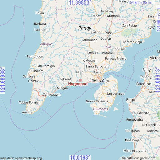
Napnapan GPS coordinates[2]
10° 42' 30.42" North, 122° 23' 34.8" East
| Map corner | latitude | longitude |
|---|---|---|
| Upper-left | 11.39853°, | 121.68988° |
| Center: | 10.70845°, | 122.393° |
| Lower-right: | 10.0168°, | 123.09613° |
| Map W x H: | 153.6×153.6 km | = 95.4×95.4mi |
| max Lat: | 20.78733° ⇑60.7% North |
| Napnapan: | 10.70845° |
| min Lat: | ⇓39.3% South 4.65442° |
| min Long | Napnapan | max Long |
| 117.04868° | 122.393° | 126.58417° |
| W 43.8%⇐ | ⇒56.2% E |
Elevation
Elevation of Napnapan is 28 m = 92 ft, and this is 59.9 m = 197 ft below average elevation for this country.
| Max E: |
2262 m = 7421 ft | 44.4% |
| Avg. | 87.9 m = 288 ft | |
| Napnapan | 28 m = 92 ft | |
Min E: |
-2 m = -7 ft | 55.6% |
See also: Philippines elevation on elevation.city.
Geographical zone
Napnapan is located in North Torrid zone (between Equator and Tropic of Cancer). Distance of Equator is 1190.7 km =739.9 mi to South.| Distance of | km | miles | from Napnapan |
|---|---|---|---|
| North Pole | 8816.4 | 5478.3 | to North |
| Arctic Circle | 6210.5 | 3859 | to North |
| Tropic Cancer | 1415.3 | 879.4 | to North |
| Equator | 1190.7 | 739.9 | to South |


Nearby cities:
15 places around Napnapan: (largest is in red/bold)
• Atabayan
3.8 km =2.4 mi,  137°
137°
• Buray
7.3 km =4.5 mi,  84°
84°
• Buyuan
5.7 km =3.5 mi,  222°
222°
• Cagbang
11.6 km =7.2 mi,  94°
94°
• Cordova
2.6 km =1.6 mi,  20°
20°
• Guimbal
9.2 km =5.7 mi,  236°
236°
• Igcocolo
8.3 km =5.2 mi,  255°
255°
• Leon
8.1 km =5 mi,  357°
357°
• Oton
9 km =5.6 mi,  100°
100°
• San Miguel
11.2 km =7 mi,  44°
44°
• San Nicolas
11.5 km =7.1 mi, 103°
• Santa Monica
7.3 km =4.5 mi,  64°
64°
• Tigbauan
4.1 km =2.5 mi,  204°
204°
• Trapiche
5.1 km =3.2 mi,  122°
122°
• Tubungan
10.3 km =6.4 mi,  306°
306°
Sources, notices
• [Note1] Compared only with cities in Philippines existing in our database
• [Src1] Map data: © OpenStreetMap contributors (CC-BY-SA)
• [Src2] Other city data from geonames.org with taken over terms of usage.
• [Src3] Geographical zone / Annual Mean Temperature by Robert A. Rohde @ Wikipedia
