Lapinigan geodata
Lapinigan (Caraga) is a populated place; located in Philippines in Asia/Manila (GMT+8) time zone. With population of 4,328 people, there are 1572 cities with bigger population in this country. Compared to other cities in Philippines, 79.3% of cities are located further ↑North; 97.6% of cities are located further ←West and 64.1% of cities have lower elevation than Lapinigan. Note1
Administrative division(s):
- Level 1: Caraga
- Level 2: Province of Agusan del Sur
- Level 3: San Francisco


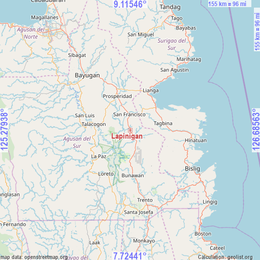
Lapinigan GPS coordinates[2]
8° 25' 14.016" North, 125° 58' 57" East
| Map corner | latitude | longitude |
|---|---|---|
| Upper-left | 9.11546°, | 125.27938° |
| Center: | 8.42056°, | 125.9825° |
| Lower-right: | 7.72441°, | 126.68563° |
| Map W x H: | 154.7×154.7 km | = 96.1×96.1mi |
| max Lat: | 20.78733° ⇑79.3% North |
| Lapinigan: | 8.42056° |
| min Lat: | ⇓20.7% South 4.65442° |
| min Long | Lapinigan | max Long |
| 117.04868° | 125.9825° | 126.58417° |
| W 97.6%⇐ | ⇒2.4% E |
Elevation
Elevation of Lapinigan is 40 m = 131 ft, and this is 47.9 m = 157 ft below average elevation for this country.
| Max E: |
2262 m = 7421 ft | 35.9% |
| Avg. | 87.9 m = 288 ft | |
| Lapinigan | 40 m = 131 ft | |
Min E: |
-2 m = -7 ft | 64.1% |
See also: Philippines elevation on elevation.city.
Geographical zone
Lapinigan is located in North Torrid zone (between Equator and Tropic of Cancer). Distance of Equator is 936.3 km =581.8 mi to South.| Distance of | km | miles | from Lapinigan |
|---|---|---|---|
| North Pole | 9070.8 | 5636.3 | to North |
| Arctic Circle | 6464.9 | 4017.1 | to North |
| Tropic Cancer | 1669.6 | 1037.4 | to North |
| Equator | 936.3 | 581.8 | to South |


Nearby cities:
15 places around Lapinigan: (largest is in red/bold)
• Alegria
10.1 km =6.3 mi,  18°
18°
• Amaga
15.6 km =9.7 mi,  38°
38°
• Aurora
24.9 km =15.5 mi,  320°
320°
• Bah-Bah
22.1 km =13.7 mi,  340°
340°
• Barobo
19.9 km =12.4 mi,  50°
50°
• Borbon
12.1 km =7.5 mi,  305°
305°
• Causwagan
15.9 km =9.9 mi,  280°
280°
• Javier
13.6 km =8.5 mi,  56°
56°
• Los Arcos
23.6 km =14.7 mi,  0°
0°
• Patin-ay
15.3 km =9.5 mi, 340°
• Prosperidad
20.1 km =12.5 mi,  331°
331°
• Rosario
4.4 km =2.7 mi,  148°
148°
• San Francisco
13.3 km =8.3 mi, 344°
• Tagbina
21.1 km =13.1 mi,  80°
80°
• Talacogon
22.2 km =13.8 mi, 280°
Sources, notices
• [Note1] Compared only with cities in Philippines existing in our database
• [Src1] Map data: © OpenStreetMap contributors (CC-BY-SA)
• [Src2] Other city data from geonames.org with taken over terms of usage.
• [Src3] Geographical zone / Annual Mean Temperature by Robert A. Rohde @ Wikipedia
