Talacogon geodata
Talacogon (Caraga) is a seat of a third-order administrative division; located in Philippines in Asia/Manila (GMT+8) time zone. With population of 15,581 people, there are 433 cities with bigger population in this country. Compared to other cities in Philippines, 79.1% of cities are located further ↑North; 96.5% of cities are located further ←West and 54.5% of cities have higher elevation than Talacogon. Note1


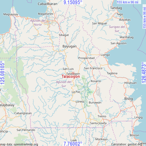
Talacogon GPS coordinates[2]
8° 27' 21.996" North, 125° 47' 3.012" East
| Map corner | latitude | longitude |
|---|---|---|
| Upper-left | 9.15095°, | 125.08105° |
| Center: | 8.45611°, | 125.78417° |
| Lower-right: | 7.76002°, | 126.4873° |
| Map W x H: | 154.7×154.7 km | = 96.1×96.1mi |
| max Lat: | 20.78733° ⇑79.1% North |
| Talacogon: | 8.45611° |
| min Lat: | ⇓20.9% South 4.65442° |
| min Long | Talacogon | max Long |
| 117.04868° | 125.78417° | 126.58417° |
| W 96.5%⇐ | ⇒3.5% E |
Elevation
Elevation of Talacogon is 20 m = 66 ft, and this is 67.9 m = 223 ft below average elevation for this country.
| Max E: |
2262 m = 7421 ft | 54.5% |
| Avg. | 87.9 m = 288 ft | |
| Talacogon | 20 m = 66 ft | |
Min E: |
-2 m = -7 ft | 45.5% |
See also: Philippines elevation on elevation.city.
Geographical zone
Talacogon is located in North Torrid zone (between Equator and Tropic of Cancer). Distance of Equator is 940.2 km =584.2 mi to South.| Distance of | km | miles | from Talacogon |
|---|---|---|---|
| North Pole | 9066.8 | 5633.8 | to North |
| Arctic Circle | 6460.9 | 4014.6 | to North |
| Tropic Cancer | 1665.7 | 1035 | to North |
| Equator | 940.2 | 584.2 | to South |


Nearby cities:
15 places around Talacogon: (largest is in red/bold)
• Alegria
25.7 km =16 mi,  77°
77°
• Aurora
16.3 km =10.1 mi,  21°
21°
• Bah-Bah
22.1 km =13.7 mi,  40°
40°
• Binucayan
24.1 km =15 mi,  197°
197°
• Borbon
12.4 km =7.7 mi, 75°
• Causwagan
6.2 km =3.9 mi,  98°
98°
• Guadalupe
16.4 km =10.2 mi,  329°
329°
• Kauswagan
7.7 km =4.8 mi, 330°
• La Paz
20.7 km =12.9 mi,  175°
175°
• Lapinigan
22.2 km =13.8 mi, 100°
• Patin-ay
19.8 km =12.3 mi,  58°
58°
• Prosperidad
18.5 km =11.5 mi, 41°
• Rosario
25.3 km =15.7 mi,  107°
107°
• San Francisco
20.3 km =12.6 mi, 64°
• San Luis
5.1 km =3.2 mi,  298°
298°
Sources, notices
• [Note1] Compared only with cities in Philippines existing in our database
• [Src1] Map data: © OpenStreetMap contributors (CC-BY-SA)
• [Src2] Other city data from geonames.org with taken over terms of usage.
• [Src3] Geographical zone / Annual Mean Temperature by Robert A. Rohde @ Wikipedia
