Bah-Bah geodata
Bah-Bah (Caraga) is a populated place; located in Philippines in Asia/Manila (GMT+8) time zone. With population of 28,643 people, there are 286 cities with bigger population in this country. Compared to other cities in Philippines, 77.6% of cities are located further ↑North; 97.1% of cities are located further ←West and 65.9% of cities have lower elevation than Bah-Bah. Note1
Administrative division(s):
- Level 1: Caraga
- Level 2: Province of Agusan del Sur
- Level 3: Prosperidad


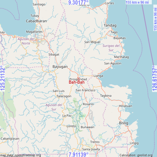
Bah-Bah GPS coordinates[2]
8° 36' 25.992" North, 125° 54' 51.984" East
| Map corner | latitude | longitude |
|---|---|---|
| Upper-left | 9.30177°, | 125.21132° |
| Center: | 8.60722°, | 125.91444° |
| Lower-right: | 7.91139°, | 126.61757° |
| Map W x H: | 154.6×154.6 km | = 96.1×96.1mi |
| max Lat: | 20.78733° ⇑77.6% North |
| Bah-Bah: | 8.60722° |
| min Lat: | ⇓22.4% South 4.65442° |
| min Long | Bah-Bah | max Long |
| 117.04868° | 125.91444° | 126.58417° |
| W 97.1%⇐ | ⇒2.9% E |
Elevation
Elevation of Bah-Bah is 43 m = 141 ft, and this is 44.9 m = 147 ft below average elevation for this country.
| Max E: |
2262 m = 7421 ft | 34.1% |
| Avg. | 87.9 m = 288 ft | |
| Bah-Bah | 43 m = 141 ft | |
Min E: |
-2 m = -7 ft | 65.9% |
See also: Philippines elevation on elevation.city.
Geographical zone
Bah-Bah is located in North Torrid zone (between Equator and Tropic of Cancer). Distance of Equator is 957 km =594.7 mi to South.| Distance of | km | miles | from Bah-Bah |
|---|---|---|---|
| North Pole | 9050 | 5623.4 | to North |
| Arctic Circle | 6444.1 | 4004.2 | to North |
| Tropic Cancer | 1648.9 | 1024.6 | to North |
| Equator | 957 | 594.7 | to South |


Nearby cities:
15 places around Bah-Bah: (largest is in red/bold)
• Alegria
15.5 km =9.6 mi,  136°
136°
• Amaga
19.1 km =11.9 mi,  116°
116°
• Aurora
8.6 km =5.3 mi,  259°
259°
• Borbon
13.9 km =8.6 mi,  189°
189°
• Causwagan
19.5 km =12.1 mi,  204°
204°
• Guadalupe
22.9 km =14.2 mi, 263°
• Javier
22.9 km =14.2 mi,  125°
125°
• Kauswagan
20.7 km =12.9 mi,  240°
240°
• Lapinigan
22.1 km =13.7 mi,  160°
160°
• Lianga
20 km =12.4 mi,  81°
81°
• Los Arcos
8.3 km =5.2 mi,  70°
70°
• Patin-ay
6.8 km =4.2 mi, 158°
• Prosperidad
3.6 km =2.2 mi,  213°
213°
• San Francisco
8.9 km =5.5 mi,  153°
153°
• Talacogon
22.1 km =13.7 mi,  220°
220°
Sources, notices
• [Note1] Compared only with cities in Philippines existing in our database
• [Src1] Map data: © OpenStreetMap contributors (CC-BY-SA)
• [Src2] Other city data from geonames.org with taken over terms of usage.
• [Src3] Geographical zone / Annual Mean Temperature by Robert A. Rohde @ Wikipedia
