Lanao geodata
Lanao (Central Visayas) is a populated place; located in Philippines in Asia/Manila (GMT+8) time zone. With population of 2,875 people, there are 2669 cities with bigger population in this country. Compared to other cities in Philippines, 53.8% of cities are located further ↑North; 71.5% of cities are located further ←West and 80.7% of cities have higher elevation than Lanao. Note1
Administrative division(s):
- Level 1: Central Visayas
- Level 2: Province of Cebu
- Level 3: Daanbantayan


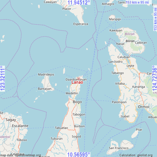
Lanao GPS coordinates[2]
11° 15' 22.896" North, 124° 1' 27.228" East
| Map corner | latitude | longitude |
|---|---|---|
| Upper-left | 11.94512°, | 123.32111° |
| Center: | 11.25636°, | 124.02423° |
| Lower-right: | 10.56595°, | 124.72736° |
| Map W x H: | 153.3×153.4 km | = 95.3×95.3mi |
| max Lat: | 20.78733° ⇑53.8% North |
| Lanao: | 11.25636° |
| min Lat: | ⇓46.2% South 4.65442° |
| min Long | Lanao | max Long |
| 117.04868° | 124.02423° | 126.58417° |
| W 71.5%⇐ | ⇒28.5% E |
Elevation
Elevation of Lanao is 9 m = 30 ft, and this is 78.9 m = 259 ft below average elevation for this country.
| Max E: |
2262 m = 7421 ft | 80.7% |
| Avg. | 87.9 m = 288 ft | |
| Lanao | 9 m = 30 ft | |
Min E: |
-2 m = -7 ft | 19.3% |
See also: Philippines elevation on elevation.city.
Geographical zone
Lanao is located in North Torrid zone (between Equator and Tropic of Cancer). Distance of Equator is 1251.6 km =777.7 mi to South.| Distance of | km | miles | from Lanao |
|---|---|---|---|
| North Pole | 8755.5 | 5440.4 | to North |
| Arctic Circle | 6149.6 | 3821.2 | to North |
| Tropic Cancer | 1354.3 | 841.5 | to North |
| Equator | 1251.6 | 777.7 | to South |


Nearby cities:
15 places around Lanao: (largest is in red/bold)
• Bachauan
8.6 km =5.3 mi,  230°
230°
• Bagay
6.8 km =4.2 mi,  170°
170°
• Biton
3.8 km =2.4 mi, 226°
• Calape
9 km =5.6 mi, 173°
• Daanbantayan
1.5 km =0.9 mi,  224°
224°
• Kauit
11.6 km =7.2 mi, 227°
• Logon
12.8 km =8 mi,  50°
50°
• Maya
3.9 km =2.4 mi,  59°
59°
• Pajo
2.2 km =1.4 mi, 221°
• Panognawan
10.7 km =6.6 mi,  191°
191°
• Paypay
7 km =4.3 mi, 228°
• Talisay
3.6 km =2.2 mi,  110°
110°
• Tapilon
2.4 km =1.5 mi,  16°
16°
• Tinubuan
8 km =5 mi, 192°
• Tominhao
2.6 km =1.6 mi,  152°
152°
Sources, notices
• [Note1] Compared only with cities in Philippines existing in our database
• [Src1] Map data: © OpenStreetMap contributors (CC-BY-SA)
• [Src2] Other city data from geonames.org with taken over terms of usage.
• [Src3] Geographical zone / Annual Mean Temperature by Robert A. Rohde @ Wikipedia
