Lacdayan geodata
Lacdayan (Calabarzon) is a populated place; located in Philippines in Asia/Manila (GMT+8) time zone. With population of 2,642 people, there are 3042 cities with bigger population in this country. Compared to other cities in Philippines, 63.2% of cities are located further ↓South; 54% of cities are located further →East and 56.1% of cities have higher elevation than Lacdayan. Note1


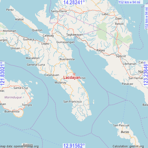
Lacdayan GPS coordinates[2]
13° 36' 0" North, 122° 31' 59.988" East
| Map corner | latitude | longitude |
|---|---|---|
| Upper-left | 14.28241°, | 121.83021° |
| Center: | 13.6°, | 122.53333° |
| Lower-right: | 12.91562°, | 123.23646° |
| Map W x H: | 152×152 km | = 94.4×94.4mi |
| max Lat: | 20.78733° ⇑36.8% North |
| Lacdayan: | 13.6° |
| min Lat: | ⇓63.2% South 4.65442° |
| min Long | Lacdayan | max Long |
| 117.04868° | 122.53333° | 126.58417° |
| W 46%⇐ | ⇒54% E |
Elevation
Elevation of Lacdayan is 19 m = 62 ft, and this is 68.9 m = 226 ft below average elevation for this country.
| Max E: |
2262 m = 7421 ft | 56.1% |
| Avg. | 87.9 m = 288 ft | |
| Lacdayan | 19 m = 62 ft | |
Min E: |
-2 m = -7 ft | 43.9% |
See also: Philippines elevation on elevation.city.
Geographical zone
Lacdayan is located in North Torrid zone (between Equator and Tropic of Cancer). Distance of this Northern Tropic circle is 1093.7 km =679.6 mi to North.| Distance of | km | miles | from Lacdayan |
|---|---|---|---|
| North Pole | 8494.9 | 5278.5 | to North |
| Arctic Circle | 5889 | 3659.3 | to North |
| Tropic Cancer | 1093.7 | 679.6 | to North |
| Equator | 1512.2 | 939.6 | to South |


Nearby cities:
15 places around Lacdayan: (largest is in red/bold)
• Abuyon
2.9 km =1.8 mi,  328°
328°
• Bagupaye
16 km =9.9 mi,  255°
255°
• Binay
13 km =8.1 mi,  147°
147°
• Bosdak
22.5 km =14 mi,  189°
189°
• Cambuga
9.2 km =5.7 mi,  281°
281°
• Catanauan
22.9 km =14.2 mi,  267°
267°
• Ibabang Tayuman
21.8 km =13.5 mi,  184°
184°
• Madulao
21 km =13 mi, 260°
• Mulanay
16.4 km =10.2 mi,  238°
238°
• Patabog
19.3 km =12 mi,  205°
205°
• San Juan
10 km =6.2 mi, 148°
• San Narciso
5.1 km =3.2 mi,  134°
134°
• Santa Rosa
17.4 km =10.8 mi,  254°
254°
• Tagbacan Ibaba
17.8 km =11.1 mi, 271°
• Yuni
21.5 km =13.4 mi, 194°
Sources, notices
• [Note1] Compared only with cities in Philippines existing in our database
• [Src1] Map data: © OpenStreetMap contributors (CC-BY-SA)
• [Src2] Other city data from geonames.org with taken over terms of usage.
• [Src3] Geographical zone / Annual Mean Temperature by Robert A. Rohde @ Wikipedia
