Patabog geodata
Patabog (Calabarzon) is a populated place; located in Philippines in Asia/Manila (GMT+8) time zone. With population of 3,149 people, there are 2360 cities with bigger population in this country. Compared to other cities in Philippines, 61.7% of cities are located further ↓South; 55.6% of cities are located further →East and 56.6% of cities have lower elevation than Patabog. Note1


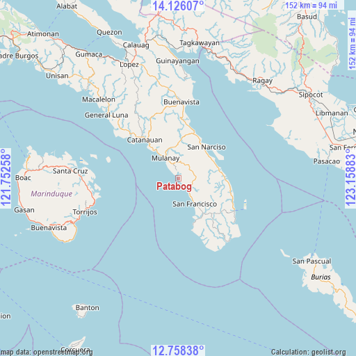
Patabog GPS coordinates[2]
13° 26' 35.52" North, 122° 27' 20.52" East
| Map corner | latitude | longitude |
|---|---|---|
| Upper-left | 14.12607°, | 121.75258° |
| Center: | 13.4432°, | 122.4557° |
| Lower-right: | 12.75838°, | 123.15883° |
| Map W x H: | 152.1×152.1 km | = 94.5×94.5mi |
| max Lat: | 20.78733° ⇑38.3% North |
| Patabog: | 13.4432° |
| min Lat: | ⇓61.7% South 4.65442° |
| min Long | Patabog | max Long |
| 117.04868° | 122.4557° | 126.58417° |
| W 44.4%⇐ | ⇒55.6% E |
Elevation
Elevation of Patabog is 29 m = 95 ft, and this is 58.9 m = 193 ft below average elevation for this country.
| Max E: |
2262 m = 7421 ft | 43.4% |
| Avg. | 87.9 m = 288 ft | |
| Patabog | 29 m = 95 ft | |
Min E: |
-2 m = -7 ft | 56.6% |
See also: Philippines elevation on elevation.city.
Geographical zone
Patabog is located in North Torrid zone (between Equator and Tropic of Cancer). Distance of this Northern Tropic circle is 1111.2 km =690.5 mi to North.| Distance of | km | miles | from Patabog |
|---|---|---|---|
| North Pole | 8512.3 | 5289.3 | to North |
| Arctic Circle | 5906.4 | 3670.1 | to North |
| Tropic Cancer | 1111.2 | 690.5 | to North |
| Equator | 1494.7 | 928.8 | to South |


Nearby cities:
15 places around Patabog: (largest is in red/bold)
• Aurora
12.7 km =7.9 mi,  147°
147°
• Bagupaye
15.3 km =9.5 mi,  332°
332°
• Binay
16.7 km =10.4 mi,  67°
67°
• Bosdak
6.8 km =4.2 mi,  135°
135°
• Cambuga
19.3 km =12 mi,  358°
358°
• Cawayan
10.3 km =6.4 mi, 145°
• Ibabang Tayuman
7.9 km =4.9 mi,  123°
123°
• Lacdayan
19.3 km =12 mi,  25°
25°
• Madulao
18.6 km =11.6 mi,  318°
318°
• Mulanay
10.4 km =6.5 mi, 327°
• San Juan
16.2 km =10.1 mi,  56°
56°
• San Narciso
18.3 km =11.4 mi,  40°
40°
• Santa Rosa
15.4 km =9.6 mi, 326°
• Silongin
17.5 km =10.9 mi,  155°
155°
• Yuni
4.6 km =2.9 mi, 137°
Sources, notices
• [Note1] Compared only with cities in Philippines existing in our database
• [Src1] Map data: © OpenStreetMap contributors (CC-BY-SA)
• [Src2] Other city data from geonames.org with taken over terms of usage.
• [Src3] Geographical zone / Annual Mean Temperature by Robert A. Rohde @ Wikipedia
