San Juan geodata
San Juan (Calabarzon) is a populated place; located in Philippines in Asia/Manila (GMT+8) time zone. With population of 2,642 people, there are 3042 cities with bigger population in this country. Compared to other cities in Philippines, 62.4% of cities are located further ↓South; 53.3% of cities are located further →East and 51.8% of cities have higher elevation than San Juan. Note1


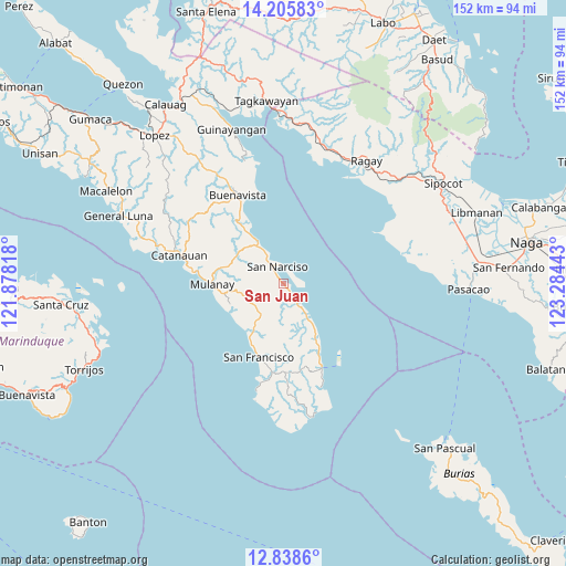
San Juan GPS coordinates[2]
13° 31' 23.52" North, 122° 34' 52.68" East
| Map corner | latitude | longitude |
|---|---|---|
| Upper-left | 14.20583°, | 121.87818° |
| Center: | 13.5232°, | 122.5813° |
| Lower-right: | 12.8386°, | 123.28443° |
| Map W x H: | 152×152 km | = 94.4×94.4mi |
| max Lat: | 20.78733° ⇑37.6% North |
| San Juan: | 13.5232° |
| min Lat: | ⇓62.4% South 4.65442° |
| min Long | San Juan | max Long |
| 117.04868° | 122.5813° | 126.58417° |
| W 46.7%⇐ | ⇒53.3% E |
Elevation
Elevation of San Juan is 22 m = 72 ft, and this is 65.9 m = 216 ft below average elevation for this country.
| Max E: |
2262 m = 7421 ft | 51.8% |
| Avg. | 87.9 m = 288 ft | |
| San Juan | 22 m = 72 ft | |
Min E: |
-2 m = -7 ft | 48.2% |
See also: Philippines elevation on elevation.city.
Geographical zone
San Juan is located in North Torrid zone (between Equator and Tropic of Cancer). Distance of this Northern Tropic circle is 1102.3 km =684.9 mi to North.| Distance of | km | miles | from San Juan |
|---|---|---|---|
| North Pole | 8503.4 | 5283.8 | to North |
| Arctic Circle | 5897.5 | 3664.5 | to North |
| Tropic Cancer | 1102.3 | 684.9 | to North |
| Equator | 1503.6 | 934.3 | to South |


Nearby cities:
15 places around San Juan: (largest is in red/bold)
• Abuyon
12.9 km =8 mi,  328°
328°
• Aurora
20.6 km =12.8 mi,  198°
198°
• Bagupaye
21.2 km =13.2 mi,  282°
282°
• Binay
3 km =1.9 mi,  142°
142°
• Bosdak
16.3 km =10.1 mi,  212°
212°
• Cambuga
17.6 km =10.9 mi,  306°
306°
• Camp Flora
21.2 km =13.2 mi,  154°
154°
• Cawayan
19 km =11.8 mi, 204°
• Ibabang Tayuman
15 km =9.3 mi, 207°
• Lacdayan
10 km =6.2 mi, 328°
• Mulanay
19.1 km =11.9 mi,  269°
269°
• Patabog
16.2 km =10.1 mi,  236°
236°
• San Narciso
5.2 km =3.2 mi,  342°
342°
• Santa Rosa
22.4 km =13.9 mi, 280°
• Yuni
16.2 km =10.1 mi,  220°
220°
Sources, notices
• [Note1] Compared only with cities in Philippines existing in our database
• [Src1] Map data: © OpenStreetMap contributors (CC-BY-SA)
• [Src2] Other city data from geonames.org with taken over terms of usage.
• [Src3] Geographical zone / Annual Mean Temperature by Robert A. Rohde @ Wikipedia
