Labangan geodata
Labangan (Zamboanga Peninsula) is a populated place; located in Philippines in Asia/Manila (GMT+8) time zone. With population of 10,780 people, there are 574 cities with bigger population in this country. Compared to other cities in Philippines, 83.7% of cities are located further ↑North; 62.4% of cities are located further ←West and 85.4% of cities have higher elevation than Labangan. Note1
Administrative division(s):
- Level 1: Zamboanga Peninsula
- Level 2: Province of Zamboanga del Sur
- Level 3: Labangan


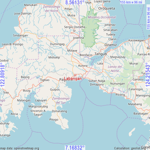
Labangan GPS coordinates[2]
7° 51' 55.44" North, 123° 30' 44.28" East
| Map corner | latitude | longitude |
|---|---|---|
| Upper-left | 8.56131°, | 122.80918° |
| Center: | 7.8654°, | 123.5123° |
| Lower-right: | 7.16832°, | 124.21543° |
| Map W x H: | 154.9×154.9 km | = 96.3×96.3mi |
| max Lat: | 20.78733° ⇑83.7% North |
| Labangan: | 7.8654° |
| min Lat: | ⇓16.3% South 4.65442° |
| min Long | Labangan | max Long |
| 117.04868° | 123.5123° | 126.58417° |
| W 62.4%⇐ | ⇒37.6% E |
Elevation
Elevation of Labangan is 8 m = 26 ft, and this is 79.9 m = 262 ft below average elevation for this country.
| Max E: |
2262 m = 7421 ft | 85.4% |
| Avg. | 87.9 m = 288 ft | |
| Labangan | 8 m = 26 ft | |
Min E: |
-2 m = -7 ft | 14.6% |
See also: Philippines elevation on elevation.city.
Geographical zone
Labangan is located in North Torrid zone (between Equator and Tropic of Cancer). Distance of Equator is 874.6 km =543.5 mi to South.| Distance of | km | miles | from Labangan |
|---|---|---|---|
| North Pole | 9132.5 | 5674.7 | to North |
| Arctic Circle | 6526.6 | 4055.4 | to North |
| Tropic Cancer | 1731.4 | 1075.8 | to North |
| Equator | 874.6 | 543.5 | to South |


Nearby cities:
15 places around Labangan: (largest is in red/bold)
• Aurora
12.2 km =7.6 mi,  39°
39°
• Danlugan
15.6 km =9.7 mi,  280°
280°
• Dumalinao
16.6 km =10.3 mi,  251°
251°
• Gubaan
13.4 km =8.3 mi,  25°
25°
• Kagawasan
12.9 km =8 mi,  270°
270°
• Lapining
20.4 km =12.7 mi,  71°
71°
• Margos
17.8 km =11.1 mi, 65°
• Muricay
5.6 km =3.5 mi,  221°
221°
• Pagadian
9.4 km =5.8 mi,  241°
241°
• Ramon Magsaysay
15.2 km =9.4 mi,  358°
358°
• Robonkon
16.2 km =10.1 mi, 219°
• Taguitic
15.4 km =9.6 mi,  58°
58°
• Tawagan
4.7 km =2.9 mi, 240°
• Tiparak
18.8 km =11.7 mi,  5°
5°
• Tucuran
7 km =4.3 mi,  101°
101°
Sources, notices
• [Note1] Compared only with cities in Philippines existing in our database
• [Src1] Map data: © OpenStreetMap contributors (CC-BY-SA)
• [Src2] Other city data from geonames.org with taken over terms of usage.
• [Src3] Geographical zone / Annual Mean Temperature by Robert A. Rohde @ Wikipedia
