Kumalarang geodata
Kumalarang (Zamboanga Peninsula) is a populated place; located in Philippines in Asia/Manila (GMT+8) time zone. With population of 6,869 people, there are 905 cities with bigger population in this country. Compared to other cities in Philippines, 84.8% of cities are located further ↑North; 55.7% of cities are located further ←West and 92.7% of cities have higher elevation than Kumalarang. Note1
Administrative division(s):
- Level 1: Zamboanga Peninsula
- Level 2: Province of Zamboanga del Sur
- Level 3: Kumalarang


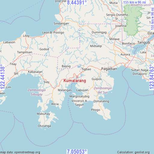
Kumalarang GPS coordinates[2]
7° 44' 52.08" North, 123° 8' 40.2" East
| Map corner | latitude | longitude |
|---|---|---|
| Upper-left | 8.44391°, | 122.44138° |
| Center: | 7.7478°, | 123.1445° |
| Lower-right: | 7.05053°, | 123.84763° |
| Map W x H: | 154.9×154.9 km | = 96.3×96.3mi |
| max Lat: | 20.78733° ⇑84.8% North |
| Kumalarang: | 7.7478° |
| min Lat: | ⇓15.2% South 4.65442° |
| min Long | Kumalarang | max Long |
| 117.04868° | 123.1445° | 126.58417° |
| W 55.7%⇐ | ⇒44.3% E |
Elevation
Elevation of Kumalarang is 6 m = 20 ft, and this is 81.9 m = 269 ft below average elevation for this country.
| Max E: |
2262 m = 7421 ft | 92.7% |
| Avg. | 87.9 m = 288 ft | |
| Kumalarang | 6 m = 20 ft | |
Min E: |
-2 m = -7 ft | 7.3% |
See also: Philippines elevation on elevation.city.
Geographical zone
Kumalarang is located in North Torrid zone (between Equator and Tropic of Cancer). Distance of Equator is 861.5 km =535.3 mi to South.| Distance of | km | miles | from Kumalarang |
|---|---|---|---|
| North Pole | 9145.6 | 5682.8 | to North |
| Arctic Circle | 6539.7 | 4063.6 | to North |
| Tropic Cancer | 1744.4 | 1083.9 | to North |
| Equator | 861.5 | 535.3 | to South |


Nearby cities:
15 places around Kumalarang: (largest is in red/bold)
• Bayog
15.8 km =9.8 mi,  327°
327°
• Buug
9.6 km =6 mi,  257°
257°
• Del Monte
15.2 km =9.4 mi, 260°
• Diplahan
14.5 km =9 mi, 256°
• Dipolo
5 km =3.1 mi,  320°
320°
• Guipos
19.9 km =12.4 mi,  100°
100°
• Kalian
19.9 km =12.4 mi,  150°
150°
• La Dicha
17.6 km =10.9 mi,  242°
242°
• Lapuyan
13.4 km =8.3 mi,  155°
155°
• Legrada
21.7 km =13.5 mi,  125°
125°
• Malangas
18 km =11.2 mi,  223°
223°
• Margosatubig
19.1 km =11.9 mi,  172°
172°
• Rancheria Payau
11.9 km =7.4 mi,  8°
8°
• San Miguel
17.5 km =10.9 mi, 129°
• Tiguha
8.8 km =5.5 mi,  123°
123°
Sources, notices
• [Note1] Compared only with cities in Philippines existing in our database
• [Src1] Map data: © OpenStreetMap contributors (CC-BY-SA)
• [Src2] Other city data from geonames.org with taken over terms of usage.
• [Src3] Geographical zone / Annual Mean Temperature by Robert A. Rohde @ Wikipedia
