Tiguha geodata
Tiguha (Zamboanga Peninsula) is a populated place; located in Philippines in Asia/Manila (GMT+8) time zone. With population of 2,142 people, there are 4006 cities with bigger population in this country. Compared to other cities in Philippines, 85.1% of cities are located further ↑North; 56.9% of cities are located further ←West and 91.4% of cities have lower elevation than Tiguha. Note1
Administrative division(s):
- Level 1: Zamboanga Peninsula
- Level 2: Province of Zamboanga del Sur
- Level 3: Lapuyan


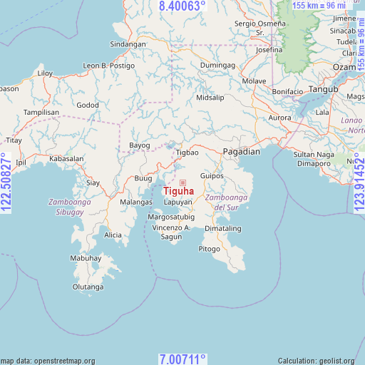
Tiguha GPS coordinates[2]
7° 42' 15.984" North, 123° 12' 41.004" East
| Map corner | latitude | longitude |
|---|---|---|
| Upper-left | 8.40063°, | 122.50827° |
| Center: | 7.70444°, | 123.21139° |
| Lower-right: | 7.00711°, | 123.91452° |
| Map W x H: | 154.9×154.9 km | = 96.3×96.3mi |
| max Lat: | 20.78733° ⇑85.1% North |
| Tiguha: | 7.70444° |
| min Lat: | ⇓14.9% South 4.65442° |
| min Long | Tiguha | max Long |
| 117.04868° | 123.21139° | 126.58417° |
| W 56.9%⇐ | ⇒43.1% E |
Elevation
Elevation of Tiguha is 266 m = 873 ft, and this is 178.1 m = 584 ft above average elevation for this country.
| Max E: |
2262 m = 7421 ft | 8.6% |
| Tiguha | 266 m 873 ft | |
| Avg. | 87.9 m = 288 ft | |
Min E: |
-2 m = -7 ft | 91.4% |
See also: Philippines elevation on elevation.city.
Geographical zone
Tiguha is located in North Torrid zone (between Equator and Tropic of Cancer). Distance of Equator is 856.7 km =532.3 mi to South.| Distance of | km | miles | from Tiguha |
|---|---|---|---|
| North Pole | 9150.4 | 5685.8 | to North |
| Arctic Circle | 6544.5 | 4066.6 | to North |
| Tropic Cancer | 1749.3 | 1087 | to North |
| Equator | 856.7 | 532.3 | to South |


Nearby cities:
15 places around Tiguha: (largest is in red/bold)
• Binuatan
17.9 km =11.1 mi,  125°
125°
• Buug
16.9 km =10.5 mi,  279°
279°
• Dipolo
13.7 km =8.5 mi,  309°
309°
• East Migpulao
18.1 km =11.2 mi,  116°
116°
• Guiniculalay
20.5 km =12.7 mi,  105°
105°
• Guipos
12.2 km =7.6 mi,  83°
83°
• Kalian
12.7 km =7.9 mi,  169°
169°
• Kumalarang
8.8 km =5.5 mi,  303°
303°
• Lapuyan
7.6 km =4.7 mi,  194°
194°
• Legrada
13 km =8.1 mi, 127°
• Lumbog
16.3 km =10.1 mi,  183°
183°
• Margosatubig
15 km =9.3 mi,  199°
199°
• Rancheria Payau
17.6 km =10.9 mi,  341°
341°
• Sagacad
14.4 km =8.9 mi,  98°
98°
• San Miguel
8.8 km =5.5 mi,  135°
135°
Sources, notices
• [Note1] Compared only with cities in Philippines existing in our database
• [Src1] Map data: © OpenStreetMap contributors (CC-BY-SA)
• [Src2] Other city data from geonames.org with taken over terms of usage.
• [Src3] Geographical zone / Annual Mean Temperature by Robert A. Rohde @ Wikipedia
