Guipos geodata
Guipos (Zamboanga Peninsula) is a populated place; located in Philippines in Asia/Manila (GMT+8) time zone. With population of 4,050 people, there are 1700 cities with bigger population in this country. Compared to other cities in Philippines, 85% of cities are located further ↑North; 58.8% of cities are located further ←West and 90.8% of cities have lower elevation than Guipos. Note1
Administrative division(s):
- Level 1: Zamboanga Peninsula
- Level 2: Province of Zamboanga del Sur
- Level 3: Guipos


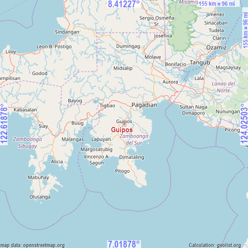
Guipos GPS coordinates[2]
7° 42' 57.96" North, 123° 19' 18.84" East
| Map corner | latitude | longitude |
|---|---|---|
| Upper-left | 8.41227°, | 122.61878° |
| Center: | 7.7161°, | 123.3219° |
| Lower-right: | 7.01878°, | 124.02503° |
| Map W x H: | 154.9×154.9 km | = 96.3×96.3mi |
| max Lat: | 20.78733° ⇑85% North |
| Guipos: | 7.7161° |
| min Lat: | ⇓15% South 4.65442° |
| min Long | Guipos | max Long |
| 117.04868° | 123.3219° | 126.58417° |
| W 58.8%⇐ | ⇒41.2% E |
Elevation
Elevation of Guipos is 249 m = 817 ft, and this is 161.1 m = 529 ft above average elevation for this country.
| Max E: |
2262 m = 7421 ft | 9.2% |
| Guipos | 249 m 817 ft | |
| Avg. | 87.9 m = 288 ft | |
Min E: |
-2 m = -7 ft | 90.8% |
See also: Philippines elevation on elevation.city.
Geographical zone
Guipos is located in North Torrid zone (between Equator and Tropic of Cancer). Distance of Equator is 857.9 km =533.1 mi to South.| Distance of | km | miles | from Guipos |
|---|---|---|---|
| North Pole | 9149.1 | 5685 | to North |
| Arctic Circle | 6543.2 | 4065.8 | to North |
| Tropic Cancer | 1748 | 1086.2 | to North |
| Equator | 857.9 | 533.1 | to South |


Nearby cities:
15 places around Guipos: (largest is in red/bold)
• Binuatan
11.8 km =7.3 mi,  168°
168°
• Dumalinao
12.6 km =7.8 mi,  24°
24°
• East Migpulao
10.2 km =6.3 mi,  156°
156°
• Guiniculalay
10.2 km =6.3 mi,  131°
131°
• Kagawasan
18.5 km =11.5 mi,  25°
25°
• Kalian
17 km =10.6 mi,  215°
215°
• Kumalarang
19.9 km =12.4 mi,  280°
280°
• Lapuyan
16.5 km =10.3 mi,  238°
238°
• Legrada
9.4 km =5.8 mi,  191°
191°
• Pagadian
17.6 km =10.9 mi,  46°
46°
• Robonkon
11.4 km =7.1 mi,  68°
68°
• Sagacad
3.9 km =2.4 mi,  148°
148°
• San Miguel
9.6 km =6 mi, 218°
• San Pablo
16.7 km =10.4 mi,  113°
113°
• Tiguha
12.2 km =7.6 mi,  263°
263°
Sources, notices
• [Note1] Compared only with cities in Philippines existing in our database
• [Src1] Map data: © OpenStreetMap contributors (CC-BY-SA)
• [Src2] Other city data from geonames.org with taken over terms of usage.
• [Src3] Geographical zone / Annual Mean Temperature by Robert A. Rohde @ Wikipedia
