Kling geodata
Kling (Soccsksargen) is a populated place; located in Philippines in Asia/Manila (GMT+8) time zone. With population of 849 people, there are 4165 cities with bigger population in this country. Compared to other cities in Philippines, 98.4% of cities are located further ↑North; 82.7% of cities are located further ←West and 62.8% of cities have higher elevation than Kling. Note1


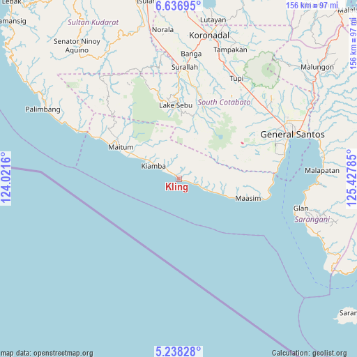
Kling GPS coordinates[2]
5° 56' 17.016" North, 124° 43' 28.992" East
| Map corner | latitude | longitude |
|---|---|---|
| Upper-left | 6.63695°, | 124.0216° |
| Center: | 5.93806°, | 124.72472° |
| Lower-right: | 5.23828°, | 125.42785° |
| Map W x H: | 155.5×155.5 km | = 96.6×96.6mi |
| max Lat: | 20.78733° ⇑98.4% North |
| Kling: | 5.93806° |
| min Lat: | ⇓1.6% South 4.65442° |
| min Long | Kling | max Long |
| 117.04868° | 124.72472° | 126.58417° |
| W 82.7%⇐ | ⇒17.3% E |
Elevation
Elevation of Kling is 15 m = 49 ft, and this is 72.9 m = 239 ft below average elevation for this country.
| Max E: |
2262 m = 7421 ft | 62.8% |
| Avg. | 87.9 m = 288 ft | |
| Kling | 15 m = 49 ft | |
Min E: |
-2 m = -7 ft | 37.2% |
See also: Philippines elevation on elevation.city.
Geographical zone
Kling is located in North Torrid zone (between Equator and Tropic of Cancer). Distance of Equator is 660.3 km =410.3 mi to South.| Distance of | km | miles | from Kling |
|---|---|---|---|
| North Pole | 9346.8 | 5807.8 | to North |
| Arctic Circle | 6740.9 | 4188.6 | to North |
| Tropic Cancer | 1945.7 | 1209 | to North |
| Equator | 660.3 | 410.3 | to South |


Nearby cities:
15 places around Kling: (largest is in red/bold)
• Buadtasan
14.5 km =9 mi,  300°
300°
• Daliao
26.7 km =16.6 mi,  108°
108°
• Katubao
12.8 km =8 mi,  115°
115°
• Kiamba
12.5 km =7.8 mi, 297°
• Lake Sebu
31.9 km =19.8 mi,  357°
357°
• Lumatil
19.4 km =12.1 mi, 111°
• Lumazal
15 km =9.3 mi, 113°
• Lumuyon
7.3 km =4.5 mi, 109°
• Maan
1.3 km =0.8 mi, 111°
• Maasim
32.4 km =20.1 mi, 106°
• Mabay
31.5 km =19.6 mi,  294°
294°
• Maitum
27.4 km =17 mi, 294°
• Nalus
17.5 km =10.9 mi, 298°
• T'boli
31.5 km =19.6 mi,  22°
22°
• Tambilil
6.6 km =4.1 mi, 293°
Sources, notices
• [Note1] Compared only with cities in Philippines existing in our database
• [Src1] Map data: © OpenStreetMap contributors (CC-BY-SA)
• [Src2] Other city data from geonames.org with taken over terms of usage.
• [Src3] Geographical zone / Annual Mean Temperature by Robert A. Rohde @ Wikipedia
