Buadtasan geodata
Buadtasan (Soccsksargen) is a populated place; located in Philippines in Asia/Manila (GMT+8) time zone. With population of 2,174 people, there are 3939 cities with bigger population in this country. Compared to other cities in Philippines, 97.9% of cities are located further ↑North; 81.1% of cities are located further ←West and 80.7% of cities have higher elevation than Buadtasan. Note1


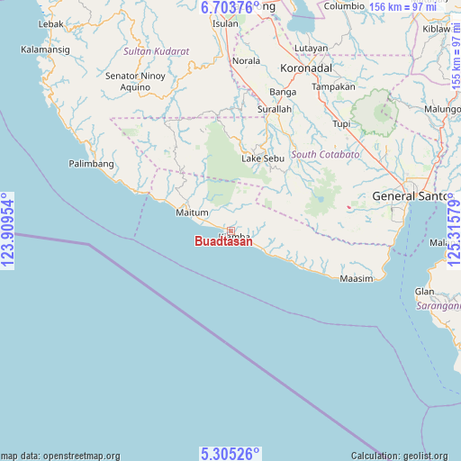
Buadtasan GPS coordinates[2]
6° 0' 17.856" North, 124° 36' 45.576" East
| Map corner | latitude | longitude |
|---|---|---|
| Upper-left | 6.70376°, | 123.90954° |
| Center: | 6.00496°, | 124.61266° |
| Lower-right: | 5.30526°, | 125.31579° |
| Map W x H: | 155.5×155.5 km | = 96.6×96.6mi |
| max Lat: | 20.78733° ⇑97.9% North |
| Buadtasan: | 6.00496° |
| min Lat: | ⇓2.1% South 4.65442° |
| min Long | Buadtasan | max Long |
| 117.04868° | 124.61266° | 126.58417° |
| W 81.1%⇐ | ⇒18.9% E |
Elevation
Elevation of Buadtasan is 9 m = 30 ft, and this is 78.9 m = 259 ft below average elevation for this country.
| Max E: |
2262 m = 7421 ft | 80.7% |
| Avg. | 87.9 m = 288 ft | |
| Buadtasan | 9 m = 30 ft | |
Min E: |
-2 m = -7 ft | 19.3% |
See also: Philippines elevation on elevation.city.
Geographical zone
Buadtasan is located in North Torrid zone (between Equator and Tropic of Cancer). Distance of Equator is 667.7 km =414.9 mi to South.| Distance of | km | miles | from Buadtasan |
|---|---|---|---|
| North Pole | 9339.4 | 5803.2 | to North |
| Arctic Circle | 6733.5 | 4184 | to North |
| Tropic Cancer | 1938.2 | 1204.3 | to North |
| Equator | 667.7 | 414.9 | to South |


Nearby cities:
15 places around Buadtasan: (largest is in red/bold)
• Katubao
27.2 km =16.9 mi,  118°
118°
• Kiamba
2.1 km =1.3 mi,  143°
143°
• Kling
14.5 km =9 mi, 120°
• Lake Sebu
26.7 km =16.6 mi,  23°
23°
• Lumazal
29.4 km =18.3 mi, 116°
• Lumuyon
21.7 km =13.5 mi, 117°
• Maan
15.7 km =9.8 mi, 120°
• Mabay
17.2 km =10.7 mi,  289°
289°
• Maguling
25.2 km =15.7 mi, 293°
• Maitum
13.2 km =8.2 mi, 286°
• Malisbeng
31.3 km =19.4 mi, 294°
• Mindupok
23 km =14.3 mi, 294°
• Nalus
3.1 km =1.9 mi,  284°
284°
• T'boli
32.6 km =20.3 mi,  48°
48°
• Tambilil
7.9 km =4.9 mi,  126°
126°
Sources, notices
• [Note1] Compared only with cities in Philippines existing in our database
• [Src1] Map data: © OpenStreetMap contributors (CC-BY-SA)
• [Src2] Other city data from geonames.org with taken over terms of usage.
• [Src3] Geographical zone / Annual Mean Temperature by Robert A. Rohde @ Wikipedia
