T'boli geodata
T'boli (Soccsksargen) is a seat of a third-order administrative division; located in Philippines in Asia/Manila (GMT+8) time zone. In our database, there are 4166 cities with bigger population. Compared to other cities in Philippines, 97.1% of cities are located further ↑North; 85.1% of cities are located further ←West and 96.8% of cities have lower elevation than T'boli. Note1
Administrative division(s):
- Level 1: Soccsksargen
- Level 2: Province of South Cotabato
- Level 3: T'Boli


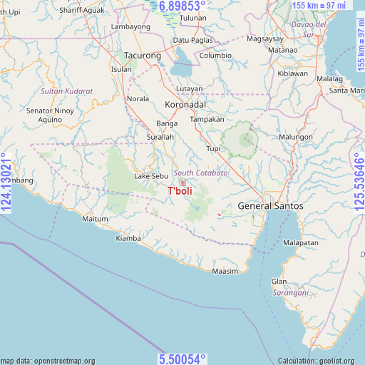
T'boli GPS coordinates[2]
6° 12' 0" North, 124° 49' 59.988" East
| Map corner | latitude | longitude |
|---|---|---|
| Upper-left | 6.89853°, | 124.13021° |
| Center: | 6.2°, | 124.83333° |
| Lower-right: | 5.50054°, | 125.53646° |
| Map W x H: | 155.4×155.4 km | = 96.6×96.6mi |
| max Lat: | 20.78733° ⇑97.1% North |
| T'boli: | 6.2° |
| min Lat: | ⇓2.9% South 4.65442° |
| min Long | T'boli | max Long |
| 117.04868° | 124.83333° | 126.58417° |
| W 85.1%⇐ | ⇒14.9% E |
Elevation
Elevation of T'boli is 587 m = 1926 ft, and this is 499.1 m = 1637 ft above average elevation for this country.
| Max E: |
2262 m = 7421 ft | 3.2% |
| T'boli | 587 m 1926 ft | |
| Avg. | 87.9 m = 288 ft | |
Min E: |
-2 m = -7 ft | 96.8% |
See also: Philippines elevation on elevation.city.
Geographical zone
T'boli is located in North Torrid zone (between Equator and Tropic of Cancer). Distance of Equator is 689.4 km =428.4 mi to South.| Distance of | km | miles | from T'boli |
|---|---|---|---|
| North Pole | 9317.7 | 5789.7 | to North |
| Arctic Circle | 6711.8 | 4170.5 | to North |
| Tropic Cancer | 1916.5 | 1190.9 | to North |
| Equator | 689.4 | 428.4 | to South |


Nearby cities:
15 places around T'boli: (largest is in red/bold)
• Colongulo
19.7 km =12.2 mi,  321°
321°
• Koronadal
17.8 km =11.1 mi,  73°
73°
• Lake Sebu
13.9 km =8.6 mi,  281°
281°
• Lamba
16.8 km =10.4 mi,  354°
354°
• Lambontong
12.3 km =7.6 mi, 348°
• Lamian
12.2 km =7.6 mi,  6°
6°
• Lampari
13.6 km =8.5 mi,  22°
22°
• Lunen
19.4 km =12.1 mi, 24°
• Pagalungan
21.2 km =13.2 mi, 69°
• Palian
21.2 km =13.2 mi, 23°
• Polonoling
17.7 km =11 mi,  57°
57°
• Sinolon
5.3 km =3.3 mi,  336°
336°
• Sulit
21.1 km =13.1 mi,  79°
79°
• Surallah
21.8 km =13.5 mi,  333°
333°
• Tupi
19.9 km =12.4 mi,  41°
41°
Sources, notices
• [Note1] Compared only with cities in Philippines existing in our database
• [Src1] Map data: © OpenStreetMap contributors (CC-BY-SA)
• [Src2] Other city data from geonames.org with taken over terms of usage.
• [Src3] Geographical zone / Annual Mean Temperature by Robert A. Rohde @ Wikipedia
