Sapang Dalaga geodata
Sapang Dalaga (Northern Mindanao) is a populated place; located in Philippines in Asia/Manila (GMT+8) time zone. With population of 2,742 people, there are 2876 cities with bigger population in this country. Compared to other cities in Philippines, 78.2% of cities are located further ↑North; 63.4% of cities are located further ←West and 82.3% of cities have lower elevation than Sapang Dalaga. Note1
Administrative division(s):
- Level 1: Northern Mindanao
- Level 2: Province of Misamis Occidental
- Level 3: Sapang Dalaga


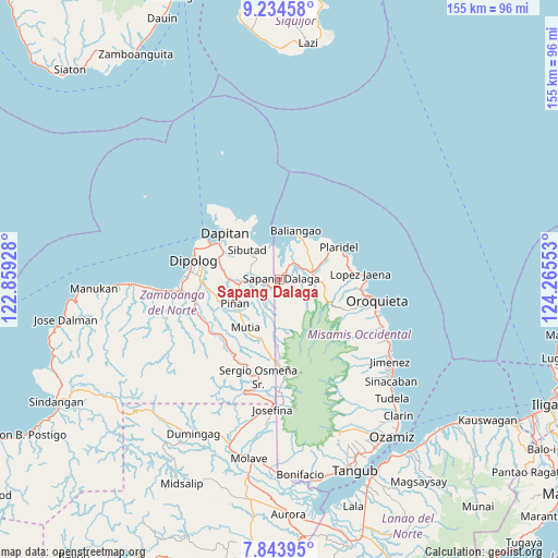
Sapang Dalaga GPS coordinates[2]
8° 32' 23.64" North, 123° 33' 44.64" East
| Map corner | latitude | longitude |
|---|---|---|
| Upper-left | 9.23458°, | 122.85928° |
| Center: | 8.5399°, | 123.5624° |
| Lower-right: | 7.84395°, | 124.26553° |
| Map W x H: | 154.6×154.6 km | = 96.1×96.1mi |
| max Lat: | 20.78733° ⇑78.2% North |
| Sapang Dalaga: | 8.5399° |
| min Lat: | ⇓21.8% South 4.65442° |
| min Long | Sapang Dalaga | max Long |
| 117.04868° | 123.5624° | 126.58417° |
| W 63.4%⇐ | ⇒36.6% E |
Elevation
Elevation of Sapang Dalaga is 109 m = 358 ft, and this is 21.1 m = 69 ft above average elevation for this country.
| Max E: |
2262 m = 7421 ft | 17.7% |
| Sapang Dalaga | 109 m 358 ft | |
| Avg. | 87.9 m = 288 ft | |
Min E: |
-2 m = -7 ft | 82.3% |
See also: Philippines elevation on elevation.city.
Geographical zone
Sapang Dalaga is located in North Torrid zone (between Equator and Tropic of Cancer). Distance of Equator is 949.5 km =590 mi to South.| Distance of | km | miles | from Sapang Dalaga |
|---|---|---|---|
| North Pole | 9057.5 | 5628.1 | to North |
| Arctic Circle | 6451.6 | 4008.8 | to North |
| Tropic Cancer | 1656.4 | 1029.2 | to North |
| Equator | 949.5 | 590 | to South |


Nearby cities:
15 places around Sapang Dalaga: (largest is in red/bold)
• Barcelona
11.5 km =7.1 mi,  263°
263°
• Bato
11.4 km =7.1 mi,  52°
52°
• Calamba
9.1 km =5.7 mi,  76°
76°
• Dapitan
20.1 km =12.5 mi,  310°
310°
• Dipolog
25.2 km =15.7 mi,  276°
276°
• Ilaya
14.5 km =9 mi,  272°
272°
• Langcangan
22.3 km =13.9 mi,  107°
107°
• Lingasan
18.5 km =11.5 mi,  254°
254°
• Lopez Jaena
21.9 km =13.6 mi,  86°
86°
• Olingan
26.5 km =16.5 mi, 269°
• Oroquieta
27.3 km =17 mi,  102°
102°
• Plaridel
18.6 km =11.6 mi,  60°
60°
• Polanco
22.1 km =13.7 mi, 267°
• Sibutao
10.2 km =6.3 mi,  304°
304°
• Unidos
13.1 km =8.1 mi, 62°
Sources, notices
• [Note1] Compared only with cities in Philippines existing in our database
• [Src1] Map data: © OpenStreetMap contributors (CC-BY-SA)
• [Src2] Other city data from geonames.org with taken over terms of usage.
• [Src3] Geographical zone / Annual Mean Temperature by Robert A. Rohde @ Wikipedia
