Juban geodata
Juban (Bicol) is a seat of a third-order administrative division; located in Philippines in Asia/Manila (GMT+8) time zone. With population of 4,075 people, there are 1678 cities with bigger population in this country. Compared to other cities in Philippines, 56.6% of cities are located further ↓South; 70.7% of cities are located further ←West and 97.1% of cities have higher elevation than Juban. Note1


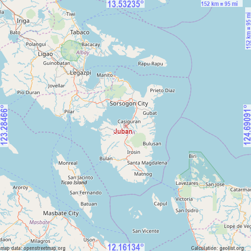
Juban GPS coordinates[2]
12° 50' 52.008" North, 123° 59' 16.008" East
| Map corner | latitude | longitude |
|---|---|---|
| Upper-left | 13.53235°, | 123.28466° |
| Center: | 12.84778°, | 123.98778° |
| Lower-right: | 12.16134°, | 124.69091° |
| Map W x H: | 152.4×152.4 km | = 94.7×94.7mi |
| max Lat: | 20.78733° ⇑43.4% North |
| Juban: | 12.84778° |
| min Lat: | ⇓56.6% South 4.65442° |
| min Long | Juban | max Long |
| 117.04868° | 123.98778° | 126.58417° |
| W 70.7%⇐ | ⇒29.3% E |
Elevation
Elevation of Juban is 4 m = 13 ft, and this is 83.9 m = 275 ft below average elevation for this country.
| Max E: |
2262 m = 7421 ft | 97.1% |
| Avg. | 87.9 m = 288 ft | |
| Juban | 4 m = 13 ft | |
Min E: |
-2 m = -7 ft | 2.9% |
See also: Philippines elevation on elevation.city.
Geographical zone
Juban is located in North Torrid zone (between Equator and Tropic of Cancer). Distance of this Northern Tropic circle is 1177.4 km =731.6 mi to North.| Distance of | km | miles | from Juban |
|---|---|---|---|
| North Pole | 8578.5 | 5330.4 | to North |
| Arctic Circle | 5972.6 | 3711.2 | to North |
| Tropic Cancer | 1177.4 | 731.6 | to North |
| Equator | 1428.5 | 887.6 | to South |


Nearby cities:
15 places around Juban: (largest is in red/bold)
• Abuyog
13 km =8.1 mi,  32°
32°
• Boton
11.1 km =6.9 mi,  35°
35°
• Buhatan
15.6 km =9.7 mi,  24°
24°
• Caditaan
15.8 km =9.8 mi,  252°
252°
• Carriedo
15.9 km =9.9 mi,  52°
52°
• Casiguran
3.7 km =2.3 mi, 39°
• Castilla
16 km =9.9 mi,  314°
314°
• Gabao
13.5 km =8.4 mi,  184°
184°
• Guruyan
13.2 km =8.2 mi,  203°
203°
• Lajong
2.8 km =1.7 mi,  234°
234°
• Monbon
13.4 km =8.3 mi,  165°
165°
• Sabang
14 km =8.7 mi, 204°
• San Roque
15.9 km =9.9 mi,  139°
139°
• Santa Cruz
8.1 km =5 mi,  66°
66°
• Sorsogon
14 km =8.7 mi,  2°
2°
Sources, notices
• [Note1] Compared only with cities in Philippines existing in our database
• [Src1] Map data: © OpenStreetMap contributors (CC-BY-SA)
• [Src2] Other city data from geonames.org with taken over terms of usage.
• [Src3] Geographical zone / Annual Mean Temperature by Robert A. Rohde @ Wikipedia
