Gabao geodata
Gabao (Bicol) is a populated place; located in Philippines in Asia/Manila (GMT+8) time zone. With population of 3,600 people, there are 1982 cities with bigger population in this country. Compared to other cities in Philippines, 56.1% of cities are located further ↓South; 70.5% of cities are located further ←West and 59.5% of cities have lower elevation than Gabao. Note1


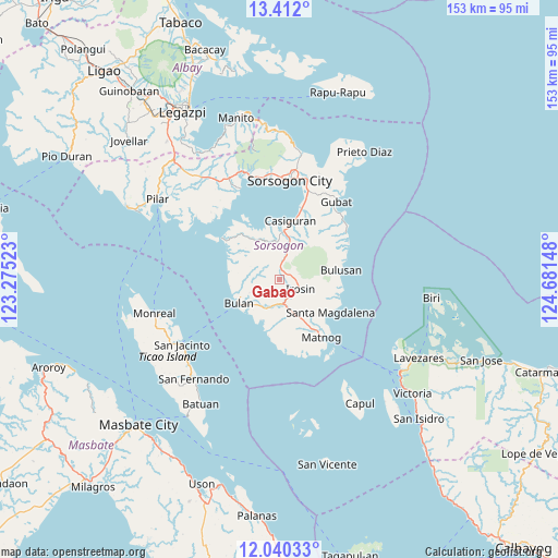
Gabao GPS coordinates[2]
12° 43' 37.524" North, 123° 58' 42.06" East
| Map corner | latitude | longitude |
|---|---|---|
| Upper-left | 13.412°, | 123.27523° |
| Center: | 12.72709°, | 123.97835° |
| Lower-right: | 12.04033°, | 124.68148° |
| Map W x H: | 152.5×152.5 km | = 94.8×94.8mi |
| max Lat: | 20.78733° ⇑43.9% North |
| Gabao: | 12.72709° |
| min Lat: | ⇓56.1% South 4.65442° |
| min Long | Gabao | max Long |
| 117.04868° | 123.97835° | 126.58417° |
| W 70.5%⇐ | ⇒29.5% E |
Elevation
Elevation of Gabao is 33 m = 108 ft, and this is 54.9 m = 180 ft below average elevation for this country.
| Max E: |
2262 m = 7421 ft | 40.5% |
| Avg. | 87.9 m = 288 ft | |
| Gabao | 33 m = 108 ft | |
Min E: |
-2 m = -7 ft | 59.5% |
See also: Philippines elevation on elevation.city.
Geographical zone
Gabao is located in North Torrid zone (between Equator and Tropic of Cancer). Distance of this Northern Tropic circle is 1190.8 km =739.9 mi to North.| Distance of | km | miles | from Gabao |
|---|---|---|---|
| North Pole | 8591.9 | 5338.8 | to North |
| Arctic Circle | 5986.1 | 3719.6 | to North |
| Tropic Cancer | 1190.8 | 739.9 | to North |
| Equator | 1415.1 | 879.3 | to South |


Nearby cities:
15 places around Gabao: (largest is in red/bold)
• Bulan
12.8 km =8 mi,  241°
241°
• Bulusan
15.7 km =9.8 mi,  80°
80°
• Butag
11.9 km =7.4 mi,  204°
204°
• Caditaan
16.5 km =10.3 mi,  301°
301°
• Casiguran
16.6 km =10.3 mi,  11°
11°
• Guruyan
4.4 km =2.7 mi,  287°
287°
• Irosin
6.6 km =4.1 mi,  117°
117°
• Juban
13.5 km =8.4 mi,  4°
4°
• Lajong
11.9 km =7.4 mi,  353°
353°
• Monbon
4.4 km =2.7 mi, 84°
• Quezon
14.5 km =9 mi,  192°
192°
• Sabang
4.9 km =3 mi,  278°
278°
• San Francisco
7.8 km =4.8 mi,  268°
268°
• San Roque
11.5 km =7.1 mi, 83°
• Utabi
12.1 km =7.5 mi,  218°
218°
Sources, notices
• [Note1] Compared only with cities in Philippines existing in our database
• [Src1] Map data: © OpenStreetMap contributors (CC-BY-SA)
• [Src2] Other city data from geonames.org with taken over terms of usage.
• [Src3] Geographical zone / Annual Mean Temperature by Robert A. Rohde @ Wikipedia
