Lajong geodata
Lajong (Bicol) is a populated place; located in Philippines in Asia/Manila (GMT+8) time zone. With population of 2,253 people, there are 3780 cities with bigger population in this country. Compared to other cities in Philippines, 56.5% of cities are located further ↓South; 70.3% of cities are located further ←West and 57.4% of cities have lower elevation than Lajong. Note1


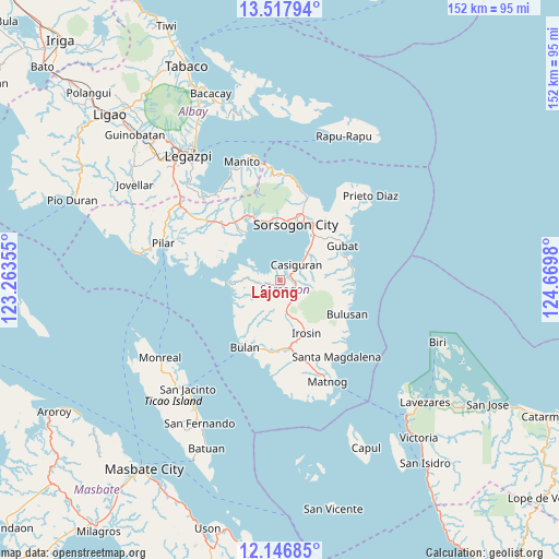
Lajong GPS coordinates[2]
12° 49' 59.988" North, 123° 58' 0.012" East
| Map corner | latitude | longitude |
|---|---|---|
| Upper-left | 13.51794°, | 123.26355° |
| Center: | 12.83333°, | 123.96667° |
| Lower-right: | 12.14685°, | 124.6698° |
| Map W x H: | 152.5×152.5 km | = 94.8×94.8mi |
| max Lat: | 20.78733° ⇑43.5% North |
| Lajong: | 12.83333° |
| min Lat: | ⇓56.5% South 4.65442° |
| min Long | Lajong | max Long |
| 117.04868° | 123.96667° | 126.58417° |
| W 70.3%⇐ | ⇒29.7% E |
Elevation
Elevation of Lajong is 30 m = 98 ft, and this is 57.9 m = 190 ft below average elevation for this country.
| Max E: |
2262 m = 7421 ft | 42.6% |
| Avg. | 87.9 m = 288 ft | |
| Lajong | 30 m = 98 ft | |
Min E: |
-2 m = -7 ft | 57.4% |
See also: Philippines elevation on elevation.city.
Geographical zone
Lajong is located in North Torrid zone (between Equator and Tropic of Cancer). Distance of this Northern Tropic circle is 1179 km =732.6 mi to North.| Distance of | km | miles | from Lajong |
|---|---|---|---|
| North Pole | 8580.1 | 5331.4 | to North |
| Arctic Circle | 5974.2 | 3712.2 | to North |
| Tropic Cancer | 1179 | 732.6 | to North |
| Equator | 1426.9 | 886.6 | to South |


Nearby cities:
15 places around Lajong: (largest is in red/bold)
• Abuyog
15.6 km =9.7 mi,  36°
36°
• Aguada
14.6 km =9.1 mi,  262°
262°
• Boton
13.8 km =8.6 mi, 39°
• Caditaan
13.1 km =8.1 mi, 256°
• Casiguran
6.5 km =4 mi,  46°
46°
• Castilla
15.8 km =9.8 mi,  324°
324°
• Gabao
11.9 km =7.4 mi,  173°
173°
• Guruyan
10.9 km =6.8 mi,  195°
195°
• Juban
2.8 km =1.7 mi, 54°
• Magallanes
14.1 km =8.8 mi,  268°
268°
• Monbon
12.7 km =7.9 mi,  153°
153°
• Sabang
11.7 km =7.3 mi, 198°
• San Francisco
13.7 km =8.5 mi,  208°
208°
• Santa Cruz
10.9 km =6.8 mi,  63°
63°
• Sorsogon
15.9 km =9.9 mi,  10°
10°
Sources, notices
• [Note1] Compared only with cities in Philippines existing in our database
• [Src1] Map data: © OpenStreetMap contributors (CC-BY-SA)
• [Src2] Other city data from geonames.org with taken over terms of usage.
• [Src3] Geographical zone / Annual Mean Temperature by Robert A. Rohde @ Wikipedia
