Castilla geodata
Castilla (Bicol) is a seat of a third-order administrative division; located in Philippines in Asia/Manila (GMT+8) time zone. With population of 2,771 people, there are 2840 cities with bigger population in this country. Compared to other cities in Philippines, 57% of cities are located further ↓South; 69.2% of cities are located further ←West and 62.8% of cities have higher elevation than Castilla. Note1


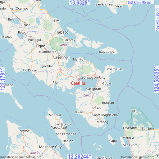
Castilla GPS coordinates[2]
12° 56' 54.996" North, 123° 52' 55.992" East
| Map corner | latitude | longitude |
|---|---|---|
| Upper-left | 13.6329°, | 123.1791° |
| Center: | 12.94861°, | 123.88222° |
| Lower-right: | 12.26244°, | 124.58535° |
| Map W x H: | 152.4×152.4 km | = 94.7×94.7mi |
| max Lat: | 20.78733° ⇑43% North |
| Castilla: | 12.94861° |
| min Lat: | ⇓57% South 4.65442° |
| min Long | Castilla | max Long |
| 117.04868° | 123.88222° | 126.58417° |
| W 69.2%⇐ | ⇒30.8% E |
Elevation
Elevation of Castilla is 15 m = 49 ft, and this is 72.9 m = 239 ft below average elevation for this country.
| Max E: |
2262 m = 7421 ft | 62.8% |
| Avg. | 87.9 m = 288 ft | |
| Castilla | 15 m = 49 ft | |
Min E: |
-2 m = -7 ft | 37.2% |
See also: Philippines elevation on elevation.city.
Geographical zone
Castilla is located in North Torrid zone (between Equator and Tropic of Cancer). Distance of this Northern Tropic circle is 1166.2 km =724.6 mi to North.| Distance of | km | miles | from Castilla |
|---|---|---|---|
| North Pole | 8567.3 | 5323.5 | to North |
| Arctic Circle | 5961.4 | 3704.2 | to North |
| Tropic Cancer | 1166.2 | 724.6 | to North |
| Equator | 1439.8 | 894.6 | to South |


Nearby cities:
15 places around Castilla: (largest is in red/bold)
• Aguada
15.6 km =9.7 mi,  199°
199°
• Basud
8.6 km =5.3 mi,  58°
58°
• Capuy
6.8 km =4.2 mi, 55°
• Cumadcad
10.7 km =6.6 mi,  289°
289°
• Gabao
15.4 km =9.6 mi,  71°
71°
• Juban
16 km =9.9 mi,  134°
134°
• Lajong
15.8 km =9.8 mi,  144°
144°
• Macalaya
13.7 km =8.5 mi,  241°
241°
• Magallanes
14.2 km =8.8 mi, 200°
• Pili
4.1 km =2.5 mi,  331°
331°
• Rizal
4.7 km =2.9 mi,  47°
47°
• San Francisco
14.5 km =9 mi,  312°
312°
• San Isidro
3.9 km =2.4 mi,  316°
316°
• San Vicente
7.3 km =4.5 mi,  296°
296°
• Sorsogon
12.4 km =7.7 mi,  76°
76°
Sources, notices
• [Note1] Compared only with cities in Philippines existing in our database
• [Src1] Map data: © OpenStreetMap contributors (CC-BY-SA)
• [Src2] Other city data from geonames.org with taken over terms of usage.
• [Src3] Geographical zone / Annual Mean Temperature by Robert A. Rohde @ Wikipedia
