Roxas City geodata
Roxas City (Western Visayas) is a seat of a second-order administrative division; located in Philippines in Asia/Manila (GMT+8) time zone. With population of 102,688 people, there are 89 cities with bigger population in this country. Compared to other cities in Philippines, 50.4% of cities are located further ↑North; 50.7% of cities are located further →East and 92.7% of cities have higher elevation than Roxas City. Note1


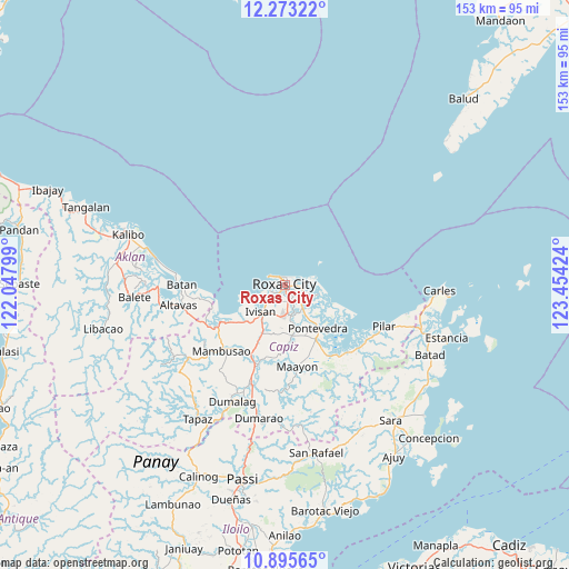
Roxas City GPS coordinates[2]
11° 35' 7.008" North, 122° 45' 3.996" East
| Map corner | latitude | longitude |
|---|---|---|
| Upper-left | 12.27322°, | 122.04799° |
| Center: | 11.58528°, | 122.75111° |
| Lower-right: | 10.89565°, | 123.45424° |
| Map W x H: | 153.2×153.2 km | = 95.2×95.2mi |
| max Lat: | 20.78733° ⇑50.4% North |
| Roxas City: | 11.58528° |
| min Lat: | ⇓49.6% South 4.65442° |
| min Long | Roxas City | max Long |
| 117.04868° | 122.75111° | 126.58417° |
| W 49.3%⇐ | ⇒50.7% E |
Elevation
Elevation of Roxas City is 6 m = 20 ft, and this is 81.9 m = 269 ft below average elevation for this country.
| Max E: |
2262 m = 7421 ft | 92.7% |
| Avg. | 87.9 m = 288 ft | |
| Roxas City | 6 m = 20 ft | |
Min E: |
-2 m = -7 ft | 7.3% |
See also: Roxas City elevation on elevation.city.
Geographical zone
Roxas City is located in North Torrid zone (between Equator and Tropic of Cancer). Distance of Equator is 1288.2 km =800.5 mi to South.| Distance of | km | miles | from Roxas City |
|---|---|---|---|
| North Pole | 8718.9 | 5417.7 | to North |
| Arctic Circle | 6113 | 3798.4 | to North |
| Tropic Cancer | 1317.8 | 818.8 | to North |
| Equator | 1288.2 | 800.5 | to South |


Nearby cities:
15 places around Roxas City: (largest is in red/bold)
• Basiao
13 km =8.1 mi,  251°
251°
• Bolo
5 km =3.1 mi,  172°
172°
• Intampilan
11.6 km =7.2 mi,  184°
184°
• Ivisan
9.7 km =6 mi,  222°
222°
• Lanot
7.4 km =4.6 mi, 174°
• Lono
8.3 km =5.2 mi,  196°
196°
• Malocloc
11.9 km =7.4 mi, 221°
• Panay
5.6 km =3.5 mi,  123°
123°
• Panitan
13.5 km =8.4 mi, 170°
• Pawa
7.6 km =4.7 mi,  109°
109°
• Sibaguan
5.1 km =3.2 mi,  232°
232°
• Tabuc Pontevedra
13.4 km =8.3 mi,  147°
147°
• Talon
8.1 km =5 mi, 249°
• Tanza
3.6 km =2.2 mi,  94°
94°
• Timpas
12 km =7.5 mi,  189°
189°
Sources, notices
• [Note1] Compared only with cities in Philippines existing in our database
• [Src1] Map data: © OpenStreetMap contributors (CC-BY-SA)
• [Src2] Other city data from geonames.org with taken over terms of usage.
• [Src3] Geographical zone / Annual Mean Temperature by Robert A. Rohde @ Wikipedia
