Amulung geodata
Amulung (Cagayan Valley) is a seat of a third-order administrative division; located in Philippines in Asia/Manila (GMT+8) time zone. With population of 2,354 people, there are 3552 cities with bigger population in this country. Compared to other cities in Philippines, 97.8% of cities are located further ↓South; 63.7% of cities are located further →East and 52.3% of cities have lower elevation than Amulung. Note1


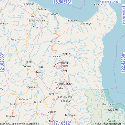
Amulung GPS coordinates[2]
17° 50' 8.52" North, 121° 43' 25.5" East
| Map corner | latitude | longitude |
|---|---|---|
| Upper-left | 18.50376°, | 121.02063° |
| Center: | 17.8357°, | 121.72375° |
| Lower-right: | 17.16512°, | 122.42688° |
| Map W x H: | 148.8×148.8 km | = 92.5×92.5mi |
| max Lat: | 20.78733° ⇑2.2% North |
| Amulung: | 17.8357° |
| min Lat: | ⇓97.8% South 4.65442° |
| min Long | Amulung | max Long |
| 117.04868° | 121.72375° | 126.58417° |
| W 36.3%⇐ | ⇒63.7% E |
Elevation
Elevation of Amulung is 25 m = 82 ft, and this is 62.9 m = 206 ft below average elevation for this country.
| Max E: |
2262 m = 7421 ft | 47.7% |
| Avg. | 87.9 m = 288 ft | |
| Amulung | 25 m = 82 ft | |
Min E: |
-2 m = -7 ft | 52.3% |
See also: Philippines elevation on elevation.city.
Geographical zone
Amulung is located in North Torrid zone (between Equator and Tropic of Cancer). Distance of this Northern Tropic circle is 622.8 km =387 mi to North.| Distance of | km | miles | from Amulung |
|---|---|---|---|
| North Pole | 8023.9 | 4985.8 | to North |
| Arctic Circle | 5418 | 3366.6 | to North |
| Tropic Cancer | 622.8 | 387 | to North |
| Equator | 1983.1 | 1232.2 | to South |


Nearby cities:
15 places around Amulung: (largest is in red/bold)
• Afusing Centro
10.4 km =6.5 mi,  280°
280°
• Alcala
10.3 km =6.4 mi,  315°
315°
• Bauan
13.4 km =8.3 mi,  200°
200°
• Bitag Grande
15.3 km =9.5 mi,  60°
60°
• Calantac
8.2 km =5.1 mi,  359°
359°
• Dalaoig
12.7 km =7.9 mi, 355°
• Dassun
10.2 km =6.3 mi,  187°
187°
• Estefania
4 km =2.5 mi,  180°
180°
• Gammad
14.1 km =8.8 mi,  171°
171°
• Iguig
9.6 km =6 mi, 171°
• Lanna
15.7 km =9.8 mi, 189°
• Minanga Norte
8.4 km =5.2 mi, 175°
• Quibal
16.2 km =10.1 mi,  145°
145°
• Taguing
12.7 km =7.9 mi,  15°
15°
• Tupang
11.7 km =7.3 mi,  311°
311°
Sources, notices
• [Note1] Compared only with cities in Philippines existing in our database
• [Src1] Map data: © OpenStreetMap contributors (CC-BY-SA)
• [Src2] Other city data from geonames.org with taken over terms of usage.
• [Src3] Geographical zone / Annual Mean Temperature by Robert A. Rohde @ Wikipedia
