Hilongos geodata
Hilongos (Eastern Visayas) is a populated place; located in Philippines in Asia/Manila (GMT+8) time zone. With population of 7,329 people, there are 849 cities with bigger population in this country. Compared to other cities in Philippines, 64.5% of cities are located further ↑North; 83.2% of cities are located further ←West and 95.5% of cities have higher elevation than Hilongos. Note1


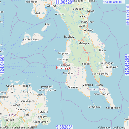
Hilongos GPS coordinates[2]
10° 22' 27.984" North, 124° 44' 58.992" East
| Map corner | latitude | longitude |
|---|---|---|
| Upper-left | 11.06529°, | 124.0466° |
| Center: | 10.37444°, | 124.74972° |
| Lower-right: | 9.68206°, | 125.45285° |
| Map W x H: | 153.8×153.8 km | = 95.6×95.6mi |
| max Lat: | 20.78733° ⇑64.5% North |
| Hilongos: | 10.37444° |
| min Lat: | ⇓35.5% South 4.65442° |
| min Long | Hilongos | max Long |
| 117.04868° | 124.74972° | 126.58417° |
| W 83.2%⇐ | ⇒16.8% E |
Elevation
Elevation of Hilongos is 5 m = 16 ft, and this is 82.9 m = 272 ft below average elevation for this country.
| Max E: |
2262 m = 7421 ft | 95.5% |
| Avg. | 87.9 m = 288 ft | |
| Hilongos | 5 m = 16 ft | |
Min E: |
-2 m = -7 ft | 4.5% |
See also: Philippines elevation on elevation.city.
Geographical zone
Hilongos is located in North Torrid zone (between Equator and Tropic of Cancer). Distance of Equator is 1153.5 km =716.8 mi to South.| Distance of | km | miles | from Hilongos |
|---|---|---|---|
| North Pole | 8853.5 | 5501.3 | to North |
| Arctic Circle | 6247.6 | 3882.1 | to North |
| Tropic Cancer | 1452.4 | 902.5 | to North |
| Equator | 1153.5 | 716.8 | to South |


Nearby cities:
15 places around Hilongos: (largest is in red/bold)
• Anahawan
14.5 km =9 mi,  104°
104°
• Bato
6.9 km =4.3 mi,  138°
138°
• Bitanjuan
24.6 km =15.3 mi,  4°
4°
• Bontoc
24.2 km =15 mi,  94°
94°
• Concepcion
5 km =3.1 mi,  46°
46°
• Doos
10.3 km =6.4 mi,  347°
347°
• Hindang
7 km =4.3 mi,  341°
341°
• Lamak
3.1 km =1.9 mi, 337°
• Maasin
28.7 km =17.8 mi,  158°
158°
• Matalom
11 km =6.8 mi, 157°
• Plaridel
21.4 km =13.3 mi, 4°
• Santa Fe
15.4 km =9.6 mi,  170°
170°
• Santa Paz
12.5 km =7.8 mi, 162°
• Sogod
25.4 km =15.8 mi, 87°
• Tabonoc
6.1 km =3.8 mi,  116°
116°
Sources, notices
• [Note1] Compared only with cities in Philippines existing in our database
• [Src1] Map data: © OpenStreetMap contributors (CC-BY-SA)
• [Src2] Other city data from geonames.org with taken over terms of usage.
• [Src3] Geographical zone / Annual Mean Temperature by Robert A. Rohde @ Wikipedia
