Doos geodata
Doos (Eastern Visayas) is a populated place; located in Philippines in Asia/Manila (GMT+8) time zone. With population of 2,744 people, there are 2872 cities with bigger population in this country. Compared to other cities in Philippines, 63.6% of cities are located further ↑North; 82.9% of cities are located further ←West and 89.7% of cities have higher elevation than Doos. Note1


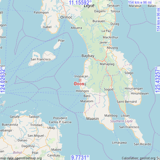
Doos GPS coordinates[2]
10° 27' 55.008" North, 124° 43' 45.984" East
| Map corner | latitude | longitude |
|---|---|---|
| Upper-left | 11.15592°, | 124.02632° |
| Center: | 10.46528°, | 124.72944° |
| Lower-right: | 9.7731°, | 125.43257° |
| Map W x H: | 153.8×153.8 km | = 95.6×95.6mi |
| max Lat: | 20.78733° ⇑63.6% North |
| Doos: | 10.46528° |
| min Lat: | ⇓36.4% South 4.65442° |
| min Long | Doos | max Long |
| 117.04868° | 124.72944° | 126.58417° |
| W 82.9%⇐ | ⇒17.1% E |
Elevation
Elevation of Doos is 7 m = 23 ft, and this is 80.9 m = 265 ft below average elevation for this country.
| Max E: |
2262 m = 7421 ft | 89.7% |
| Avg. | 87.9 m = 288 ft | |
| Doos | 7 m = 23 ft | |
Min E: |
-2 m = -7 ft | 10.3% |
See also: Philippines elevation on elevation.city.
Geographical zone
Doos is located in North Torrid zone (between Equator and Tropic of Cancer). Distance of Equator is 1163.6 km =723 mi to South.| Distance of | km | miles | from Doos |
|---|---|---|---|
| North Pole | 8843.4 | 5495 | to North |
| Arctic Circle | 6237.5 | 3875.8 | to North |
| Tropic Cancer | 1442.3 | 896.2 | to North |
| Equator | 1163.6 | 723 | to South |


Nearby cities:
15 places around Doos: (largest is in red/bold)
• Anahawan
21.2 km =13.2 mi,  129°
129°
• Bato
16.7 km =10.4 mi,  156°
156°
• Baybay
25 km =15.5 mi,  18°
18°
• Bitanjuan
15 km =9.3 mi, 15°
• Concepcion
8.9 km =5.5 mi,  138°
138°
• Hilongos
10.3 km =6.4 mi,  167°
167°
• Hindang
3.5 km =2.2 mi,  180°
180°
• Hipasngo
23.6 km =14.7 mi, 21°
• Lamak
7.4 km =4.6 mi, 171°
• Matalom
21.2 km =13.2 mi, 162°
• Palhi
22.2 km =13.8 mi, 22°
• Plaridel
11.9 km =7.4 mi, 18°
• Santa Fe
25.7 km =16 mi, 169°
• Santa Paz
22.9 km =14.2 mi, 165°
• Tabonoc
15 km =9.3 mi,  148°
148°
Sources, notices
• [Note1] Compared only with cities in Philippines existing in our database
• [Src1] Map data: © OpenStreetMap contributors (CC-BY-SA)
• [Src2] Other city data from geonames.org with taken over terms of usage.
• [Src3] Geographical zone / Annual Mean Temperature by Robert A. Rohde @ Wikipedia
