Guisijan geodata
Guisijan (Western Visayas) is a populated place; located in Philippines in Asia/Manila (GMT+8) time zone. With population of 2,196 people, there are 3895 cities with bigger population in this country. Compared to other cities in Philippines, 55.9% of cities are located further ↑North; 59.6% of cities are located further →East and 76.6% of cities have higher elevation than Guisijan. Note1


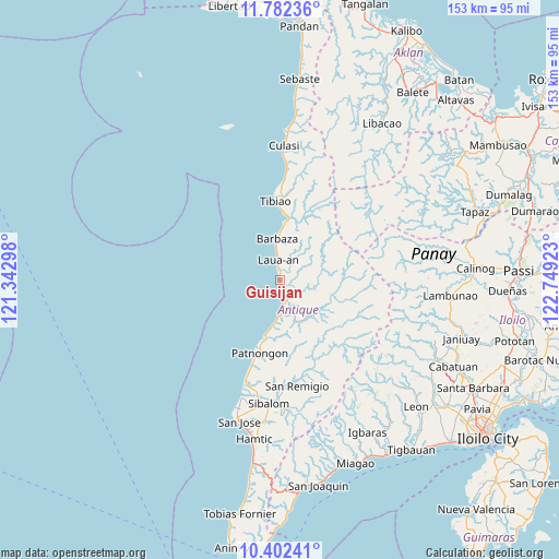
Guisijan GPS coordinates[2]
11° 5' 35.52" North, 122° 2' 45.96" East
| Map corner | latitude | longitude |
|---|---|---|
| Upper-left | 11.78236°, | 121.34298° |
| Center: | 11.0932°, | 122.0461° |
| Lower-right: | 10.40241°, | 122.74923° |
| Map W x H: | 153.4×153.4 km | = 95.3×95.3mi |
| max Lat: | 20.78733° ⇑55.9% North |
| Guisijan: | 11.0932° |
| min Lat: | ⇓44.1% South 4.65442° |
| min Long | Guisijan | max Long |
| 117.04868° | 122.0461° | 126.58417° |
| W 40.4%⇐ | ⇒59.6% E |
Elevation
Elevation of Guisijan is 10 m = 33 ft, and this is 77.9 m = 256 ft below average elevation for this country.
| Max E: |
2262 m = 7421 ft | 76.6% |
| Avg. | 87.9 m = 288 ft | |
| Guisijan | 10 m = 33 ft | |
Min E: |
-2 m = -7 ft | 23.4% |
See also: Philippines elevation on elevation.city.
Geographical zone
Guisijan is located in North Torrid zone (between Equator and Tropic of Cancer). Distance of Equator is 1233.4 km =766.4 mi to South.| Distance of | km | miles | from Guisijan |
|---|---|---|---|
| North Pole | 8773.6 | 5451.7 | to North |
| Arctic Circle | 6167.7 | 3832.4 | to North |
| Tropic Cancer | 1372.5 | 852.8 | to North |
| Equator | 1233.4 | 766.4 | to South |


Nearby cities:
15 places around Guisijan: (largest is in red/bold)
• Aurelliana
24.4 km =15.2 mi,  198°
198°
• Barbaza
11.4 km =7.1 mi,  355°
355°
• Belison
29.8 km =18.5 mi, 198°
• Bugasong
5.8 km =3.6 mi,  159°
159°
• Catungan
36 km =22.4 mi,  185°
185°
• Jayubó
37.1 km =23.1 mi,  97°
97°
• Lawa-an
6.5 km =4 mi,  347°
347°
• Malabor
20 km =12.4 mi,  0°
0°
• Patnongon
20.8 km =12.9 mi, 195°
• San Francisco
25.2 km =15.7 mi, 1°
• San Pedro
34.1 km =21.2 mi, 197°
• San Remigio
29.3 km =18.2 mi,  171°
171°
• Sibalom
33.9 km =21.1 mi, 185°
• Tibiao
22.1 km =13.7 mi, 356°
• Valderrama
35 km =21.7 mi,  6°
6°
Sources, notices
• [Note1] Compared only with cities in Philippines existing in our database
• [Src1] Map data: © OpenStreetMap contributors (CC-BY-SA)
• [Src2] Other city data from geonames.org with taken over terms of usage.
• [Src3] Geographical zone / Annual Mean Temperature by Robert A. Rohde @ Wikipedia
