Glad geodata
Glad (Soccsksargen) is a populated place; located in Philippines in Asia/Manila (GMT+8) time zone. With population of 5,746 people, there are 1108 cities with bigger population in this country. Compared to other cities in Philippines, 90.1% of cities are located further ↑North; 79.1% of cities are located further ←West and 70.2% of cities have higher elevation than Glad. Note1


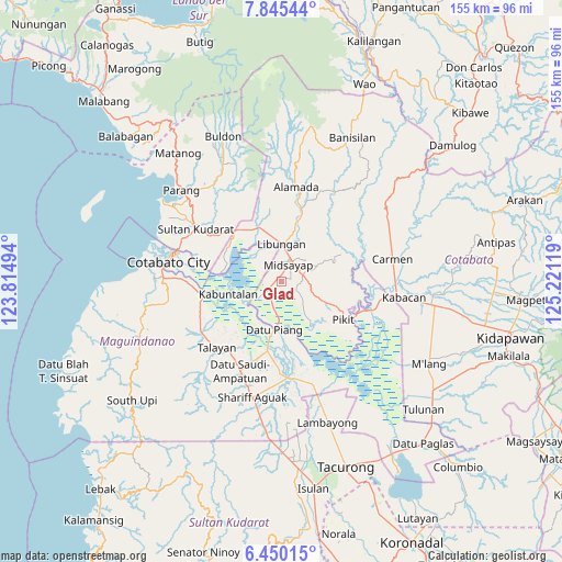
Glad GPS coordinates[2]
7° 8' 53.988" North, 124° 31' 5.016" East
| Map corner | latitude | longitude |
|---|---|---|
| Upper-left | 7.84544°, | 123.81494° |
| Center: | 7.14833°, | 124.51806° |
| Lower-right: | 6.45015°, | 125.22119° |
| Map W x H: | 155.1×155.1 km | = 96.4×96.4mi |
| max Lat: | 20.78733° ⇑90.1% North |
| Glad: | 7.14833° |
| min Lat: | ⇓9.9% South 4.65442° |
| min Long | Glad | max Long |
| 117.04868° | 124.51806° | 126.58417° |
| W 79.1%⇐ | ⇒20.9% E |
Elevation
Elevation of Glad is 12 m = 39 ft, and this is 75.9 m = 249 ft below average elevation for this country.
| Max E: |
2262 m = 7421 ft | 70.2% |
| Avg. | 87.9 m = 288 ft | |
| Glad | 12 m = 39 ft | |
Min E: |
-2 m = -7 ft | 29.8% |
See also: Philippines elevation on elevation.city.
Geographical zone
Glad is located in North Torrid zone (between Equator and Tropic of Cancer). Distance of Equator is 794.8 km =493.9 mi to South.| Distance of | km | miles | from Glad |
|---|---|---|---|
| North Pole | 9212.2 | 5724.2 | to North |
| Arctic Circle | 6606.4 | 4105 | to North |
| Tropic Cancer | 1811.1 | 1125.4 | to North |
| Equator | 794.8 | 493.9 | to South |


Nearby cities:
15 places around Glad: (largest is in red/bold)
• Baguer
12.1 km =7.5 mi,  352°
352°
• Bual
4 km =2.5 mi,  340°
340°
• Buayan
12.6 km =7.8 mi,  5°
5°
• Budta
10.6 km =6.6 mi,  305°
305°
• Dado
12.7 km =7.9 mi,  210°
210°
• Damatulan
12.8 km =8 mi,  197°
197°
• Dualing
5.6 km =3.5 mi,  86°
86°
• Libungan
10.3 km =6.4 mi,  1°
1°
• Malingao
4.9 km =3 mi,  286°
286°
• Midsayap
4.9 km =3 mi,  15°
15°
• Pagangan
9.3 km =5.8 mi,  113°
113°
• Patindeguen
8.2 km =5.1 mi, 344°
• Salunayan
2.4 km =1.5 mi, 286°
• Tomado
11.1 km =6.9 mi,  63°
63°
• Upper San Mateo
7.6 km =4.7 mi,  68°
68°
Sources, notices
• [Note1] Compared only with cities in Philippines existing in our database
• [Src1] Map data: © OpenStreetMap contributors (CC-BY-SA)
• [Src2] Other city data from geonames.org with taken over terms of usage.
• [Src3] Geographical zone / Annual Mean Temperature by Robert A. Rohde @ Wikipedia
