Libungan geodata
Libungan (Soccsksargen) is a seat of a third-order administrative division; located in Philippines in Asia/Manila (GMT+8) time zone. With population of 5,606 people, there are 1132 cities with bigger population in this country. Compared to other cities in Philippines, 89% of cities are located further ↑North; 79.2% of cities are located further ←West and 54.4% of cities have lower elevation than Libungan. Note1


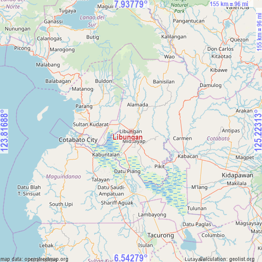
Libungan GPS coordinates[2]
7° 14' 26.988" North, 124° 31' 12" East
| Map corner | latitude | longitude |
|---|---|---|
| Upper-left | 7.93779°, | 123.81688° |
| Center: | 7.24083°, | 124.52° |
| Lower-right: | 6.54279°, | 125.22313° |
| Map W x H: | 155.1×155.1 km | = 96.4×96.4mi |
| max Lat: | 20.78733° ⇑89% North |
| Libungan: | 7.24083° |
| min Lat: | ⇓11% South 4.65442° |
| min Long | Libungan | max Long |
| 117.04868° | 124.52° | 126.58417° |
| W 79.2%⇐ | ⇒20.8% E |
Elevation
Elevation of Libungan is 27 m = 89 ft, and this is 60.9 m = 200 ft below average elevation for this country.
| Max E: |
2262 m = 7421 ft | 45.6% |
| Avg. | 87.9 m = 288 ft | |
| Libungan | 27 m = 89 ft | |
Min E: |
-2 m = -7 ft | 54.4% |
See also: Philippines elevation on elevation.city.
Geographical zone
Libungan is located in North Torrid zone (between Equator and Tropic of Cancer). Distance of Equator is 805.1 km =500.3 mi to South.| Distance of | km | miles | from Libungan |
|---|---|---|---|
| North Pole | 9202 | 5717.9 | to North |
| Arctic Circle | 6596.1 | 4098.6 | to North |
| Tropic Cancer | 1800.8 | 1119 | to North |
| Equator | 805.1 | 500.3 | to South |


Nearby cities:
15 places around Libungan: (largest is in red/bold)
• Baguer
2.4 km =1.5 mi,  314°
314°
• Balogo
7.7 km =4.8 mi, 306°
• Barongis
5.4 km =3.4 mi,  65°
65°
• Bual
6.7 km =4.2 mi,  193°
193°
• Buayan
2.5 km =1.6 mi,  24°
24°
• Budta
9.7 km =6 mi,  245°
245°
• Dualing
11.3 km =7 mi,  151°
151°
• Glad
10.3 km =6.4 mi,  181°
181°
• Malingao
10.2 km =6.3 mi,  209°
209°
• Midsayap
5.7 km =3.5 mi,  168°
168°
• Patindeguen
3.4 km =2.1 mi,  225°
225°
• Pigcawayan
11.2 km =7 mi,  291°
291°
• Salunayan
9.9 km =6.2 mi, 194°
• Tomado
11.1 km =6.9 mi,  118°
118°
• Upper San Mateo
10.2 km =6.3 mi,  137°
137°
Sources, notices
• [Note1] Compared only with cities in Philippines existing in our database
• [Src1] Map data: © OpenStreetMap contributors (CC-BY-SA)
• [Src2] Other city data from geonames.org with taken over terms of usage.
• [Src3] Geographical zone / Annual Mean Temperature by Robert A. Rohde @ Wikipedia
