Budta geodata
Budta (Autonomous Region in Muslim Mindanao) is a populated place; located in Philippines in Asia/Manila (GMT+8) time zone. With population of 1,273,715 people, there are 3 cities with bigger population in this country. Compared to other cities in Philippines, 89.5% of cities are located further ↑North; 78.1% of cities are located further ←West and 97.1% of cities have higher elevation than Budta. Note1
Administrative division(s):
- Level 1: Autonomous Region in Muslim Mindanao
- Level 2: Province of Maguindanao
- Level 3: Northern Kabuntalan


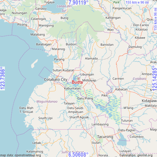
Budta GPS coordinates[2]
7° 12' 15.012" North, 124° 26' 22.992" East
| Map corner | latitude | longitude |
|---|---|---|
| Upper-left | 7.90119°, | 123.7366° |
| Center: | 7.20417°, | 124.43972° |
| Lower-right: | 6.50608°, | 125.14285° |
| Map W x H: | 155.1×155.1 km | = 96.4×96.4mi |
| max Lat: | 20.78733° ⇑89.5% North |
| Budta: | 7.20417° |
| min Lat: | ⇓10.5% South 4.65442° |
| min Long | Budta | max Long |
| 117.04868° | 124.43972° | 126.58417° |
| W 78.1%⇐ | ⇒21.9% E |
Elevation
Elevation of Budta is 4 m = 13 ft, and this is 83.9 m = 275 ft below average elevation for this country.
| Max E: |
2262 m = 7421 ft | 97.1% |
| Avg. | 87.9 m = 288 ft | |
| Budta | 4 m = 13 ft | |
Min E: |
-2 m = -7 ft | 2.9% |
See also: Budta elevation on elevation.city.
Geographical zone
Budta is located in North Torrid zone (between Equator and Tropic of Cancer). Distance of Equator is 801 km =497.7 mi to South.| Distance of | km | miles | from Budta |
|---|---|---|---|
| North Pole | 9206 | 5720.3 | to North |
| Arctic Circle | 6600.1 | 4101.1 | to North |
| Tropic Cancer | 1804.9 | 1121.5 | to North |
| Equator | 801 | 497.7 | to South |


Nearby cities:
15 places around Budta: (largest is in red/bold)
• Baguer
9.2 km =5.7 mi,  50°
50°
• Balogo
9.1 km =5.7 mi,  17°
17°
• Bongued
10.7 km =6.6 mi,  204°
204°
• Bual
7.7 km =4.8 mi,  108°
108°
• Buayan
11.7 km =7.3 mi,  57°
57°
• Glad
10.6 km =6.6 mi,  125°
125°
• Katidtuan
13.8 km =8.6 mi,  262°
262°
• Libungan
9.7 km =6 mi,  65°
65°
• Malingao
6.2 km =3.9 mi,  141°
141°
• Manuangan
9 km =5.6 mi,  334°
334°
• Midsayap
10.1 km =6.3 mi,  98°
98°
• Pagaluñgan
9.5 km =5.9 mi,  223°
223°
• Patindeguen
6.7 km =4.2 mi,  75°
75°
• Pigcawayan
8.3 km =5.2 mi,  349°
349°
• Salunayan
8.4 km =5.2 mi, 130°
Sources, notices
• [Note1] Compared only with cities in Philippines existing in our database
• [Src1] Map data: © OpenStreetMap contributors (CC-BY-SA)
• [Src2] Other city data from geonames.org with taken over terms of usage.
• [Src3] Geographical zone / Annual Mean Temperature by Robert A. Rohde @ Wikipedia
