Gabuyan geodata
Gabuyan (Davao) is a populated place; located in Philippines in Asia/Manila (GMT+8) time zone. With population of 4,402 people, there are 1538 cities with bigger population in this country. Compared to other cities in Philippines, 85.9% of cities are located further ↑North; 95.3% of cities are located further ←West and 58.1% of cities have lower elevation than Gabuyan. Note1


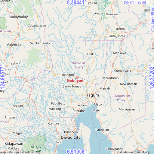
Gabuyan GPS coordinates[2]
7° 36' 29.016" North, 125° 40' 8.004" East
| Map corner | latitude | longitude |
|---|---|---|
| Upper-left | 8.30441°, | 124.96577° |
| Center: | 7.60806°, | 125.66889° |
| Lower-right: | 6.91058°, | 126.37202° |
| Map W x H: | 155×155 km | = 96.3×96.3mi |
| max Lat: | 20.78733° ⇑85.9% North |
| Gabuyan: | 7.60806° |
| min Lat: | ⇓14.1% South 4.65442° |
| min Long | Gabuyan | max Long |
| 117.04868° | 125.66889° | 126.58417° |
| W 95.3%⇐ | ⇒4.7% E |
Elevation
Elevation of Gabuyan is 31 m = 102 ft, and this is 56.9 m = 187 ft below average elevation for this country.
| Max E: |
2262 m = 7421 ft | 41.9% |
| Avg. | 87.9 m = 288 ft | |
| Gabuyan | 31 m = 102 ft | |
Min E: |
-2 m = -7 ft | 58.1% |
See also: Philippines elevation on elevation.city.
Geographical zone
Gabuyan is located in North Torrid zone (between Equator and Tropic of Cancer). Distance of Equator is 845.9 km =525.6 mi to South.| Distance of | km | miles | from Gabuyan |
|---|---|---|---|
| North Pole | 9161.1 | 5692.4 | to North |
| Arctic Circle | 6555.2 | 4073.2 | to North |
| Tropic Cancer | 1760 | 1093.6 | to North |
| Equator | 845.9 | 525.6 | to South |


Nearby cities:
15 places around Gabuyan: (largest is in red/bold)
• Buclad
12.7 km =7.9 mi,  134°
134°
• Cambanugoy
12.1 km =7.5 mi, 127°
• Kinamayan
12.1 km =7.5 mi,  177°
177°
• Luna
3.5 km =2.2 mi, 182°
• Lungaog
9 km =5.6 mi,  166°
166°
• Magatos
8.6 km =5.3 mi, 132°
• New Visayas
10.7 km =6.6 mi,  208°
208°
• Pag-asa
4 km =2.5 mi,  155°
155°
• Palma Gil
5.8 km =3.6 mi,  310°
310°
• Sampao
1.8 km =1.1 mi, 208°
• San Miguel
13.7 km =8.5 mi, 176°
• Santo Niño
5.1 km =3.2 mi,  289°
289°
• Santo Tomas
9.7 km =6 mi, 211°
• Suz-on
7 km =4.3 mi,  331°
331°
• Talomo
10.6 km =6.6 mi,  146°
146°
Sources, notices
• [Note1] Compared only with cities in Philippines existing in our database
• [Src1] Map data: © OpenStreetMap contributors (CC-BY-SA)
• [Src2] Other city data from geonames.org with taken over terms of usage.
• [Src3] Geographical zone / Annual Mean Temperature by Robert A. Rohde @ Wikipedia
