Suz-on geodata
Suz-on (Davao) is a populated place; located in Philippines in Asia/Manila (GMT+8) time zone. With population of 2,936 people, there are 2603 cities with bigger population in this country. Compared to other cities in Philippines, 85.4% of cities are located further ↑North; 94.9% of cities are located further ←West and 65.2% of cities have lower elevation than Suz-on. Note1


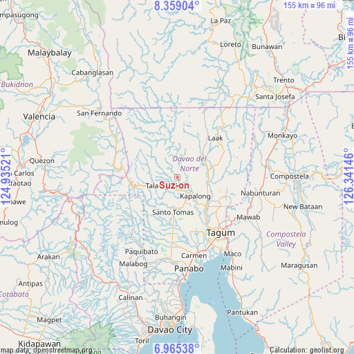
Suz-on GPS coordinates[2]
7° 39' 46.008" North, 125° 38' 17.988" East
| Map corner | latitude | longitude |
|---|---|---|
| Upper-left | 8.35904°, | 124.93521° |
| Center: | 7.66278°, | 125.63833° |
| Lower-right: | 6.96538°, | 126.34146° |
| Map W x H: | 155×155 km | = 96.3×96.3mi |
| max Lat: | 20.78733° ⇑85.4% North |
| Suz-on: | 7.66278° |
| min Lat: | ⇓14.6% South 4.65442° |
| min Long | Suz-on | max Long |
| 117.04868° | 125.63833° | 126.58417° |
| W 94.9%⇐ | ⇒5.1% E |
Elevation
Elevation of Suz-on is 42 m = 138 ft, and this is 45.9 m = 151 ft below average elevation for this country.
| Max E: |
2262 m = 7421 ft | 34.8% |
| Avg. | 87.9 m = 288 ft | |
| Suz-on | 42 m = 138 ft | |
Min E: |
-2 m = -7 ft | 65.2% |
See also: Philippines elevation on elevation.city.
Geographical zone
Suz-on is located in North Torrid zone (between Equator and Tropic of Cancer). Distance of Equator is 852 km =529.4 mi to South.| Distance of | km | miles | from Suz-on |
|---|---|---|---|
| North Pole | 9155 | 5688.7 | to North |
| Arctic Circle | 6549.2 | 4069.5 | to North |
| Tropic Cancer | 1753.9 | 1089.8 | to North |
| Equator | 852 | 529.4 | to South |


Nearby cities:
15 places around Suz-on: (largest is in red/bold)
• Concepcion
12.7 km =7.9 mi,  39°
39°
• Gabuyan
7 km =4.3 mi,  151°
151°
• Gupitan
12.6 km =7.8 mi,  1°
1°
• Kapalong
14.9 km =9.3 mi,  323°
323°
• Kinamayan
18.6 km =11.6 mi,  167°
167°
• Luna
10.1 km =6.3 mi,  161°
161°
• Lungaog
15.8 km =9.8 mi, 159°
• Magatos
15.4 km =9.6 mi,  140°
140°
• New Visayas
15.6 km =9.7 mi,  186°
186°
• Pag-asa
10.9 km =6.8 mi, 152°
• Palma Gil
2.5 km =1.6 mi,  203°
203°
• Sampao
8.1 km =5 mi, 161°
• Santo Niño
4.6 km =2.9 mi, 198°
• Santo Tomas
14.5 km =9 mi, 186°
• Talomo
17.6 km =10.9 mi, 148°
Sources, notices
• [Note1] Compared only with cities in Philippines existing in our database
• [Src1] Map data: © OpenStreetMap contributors (CC-BY-SA)
• [Src2] Other city data from geonames.org with taken over terms of usage.
• [Src3] Geographical zone / Annual Mean Temperature by Robert A. Rohde @ Wikipedia
