Bulusan geodata
Bulusan (Bicol) is a seat of a third-order administrative division; located in Philippines in Asia/Manila (GMT+8) time zone. With population of 6,648 people, there are 943 cities with bigger population in this country. Compared to other cities in Philippines, 56.2% of cities are located further ↓South; 73.2% of cities are located further ←West and 82% of cities have lower elevation than Bulusan. Note1


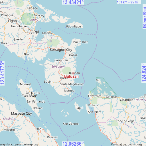
Bulusan GPS coordinates[2]
12° 44' 57.696" North, 124° 7' 15.132" East
| Map corner | latitude | longitude |
|---|---|---|
| Upper-left | 13.43421°, | 123.41775° |
| Center: | 12.74936°, | 124.12087° |
| Lower-right: | 12.06266°, | 124.824° |
| Map W x H: | 152.5×152.5 km | = 94.8×94.8mi |
| max Lat: | 20.78733° ⇑43.8% North |
| Bulusan: | 12.74936° |
| min Lat: | ⇓56.2% South 4.65442° |
| min Long | Bulusan | max Long |
| 117.04868° | 124.12087° | 126.58417° |
| W 73.2%⇐ | ⇒26.8% E |
Elevation
Elevation of Bulusan is 106 m = 348 ft, and this is 18.1 m = 59 ft above average elevation for this country.
| Max E: |
2262 m = 7421 ft | 18% |
| Bulusan | 106 m 348 ft | |
| Avg. | 87.9 m = 288 ft | |
Min E: |
-2 m = -7 ft | 82% |
See also: Philippines elevation on elevation.city.
Geographical zone
Bulusan is located in North Torrid zone (between Equator and Tropic of Cancer). Distance of this Northern Tropic circle is 1188.3 km =738.4 mi to North.| Distance of | km | miles | from Bulusan |
|---|---|---|---|
| North Pole | 8589.5 | 5337.3 | to North |
| Arctic Circle | 5983.6 | 3718 | to North |
| Tropic Cancer | 1188.3 | 738.4 | to North |
| Equator | 1417.6 | 880.9 | to South |


Nearby cities:
15 places around Bulusan: (largest is in red/bold)
• Barcelona
13.4 km =8.3 mi,  9°
9°
• Casiguran
18.3 km =11.4 mi,  318°
318°
• Gabao
15.7 km =9.8 mi,  260°
260°
• Gubat
19 km =11.8 mi,  0°
0°
• Guruyan
19.7 km =12.2 mi,  266°
266°
• Irosin
11.1 km =6.9 mi,  240°
240°
• Juban
18.1 km =11.2 mi,  307°
307°
• Lajong
19.2 km =11.9 mi,  299°
299°
• Matnog
18.3 km =11.4 mi,  191°
191°
• Monbon
11.3 km =7 mi, 259°
• Rizal
15.3 km =9.5 mi, 5°
• Sabang
20.4 km =12.7 mi, 264°
• San Roque
4.2 km =2.6 mi,  254°
254°
• Santa Cruz
15.7 km =9.8 mi,  333°
333°
• Santa Magdalena
11.3 km =7 mi, 186°
Sources, notices
• [Note1] Compared only with cities in Philippines existing in our database
• [Src1] Map data: © OpenStreetMap contributors (CC-BY-SA)
• [Src2] Other city data from geonames.org with taken over terms of usage.
• [Src3] Geographical zone / Annual Mean Temperature by Robert A. Rohde @ Wikipedia
