Esperanza geodata
Esperanza (Davao) is a populated place; located in Philippines in Asia/Manila (GMT+8) time zone. With population of 2,723 people, there are 2906 cities with bigger population in this country. Compared to other cities in Philippines, 87.1% of cities are located further ↑North; 96.1% of cities are located further ←West and 67.4% of cities have higher elevation than Esperanza. Note1
Administrative division(s):
- Level 1: Davao
- Level 2: Province of Davao del Norte
- Level 3: Santo Tomas


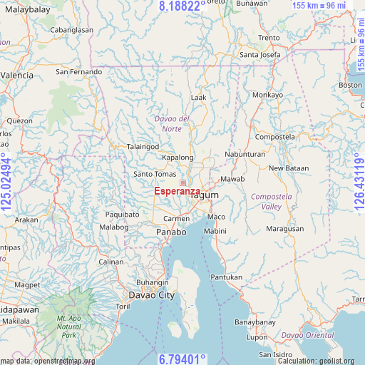
Esperanza GPS coordinates[2]
7° 29' 30.012" North, 125° 43' 41.016" East
| Map corner | latitude | longitude |
|---|---|---|
| Upper-left | 8.18822°, | 125.02494° |
| Center: | 7.49167°, | 125.72806° |
| Lower-right: | 6.79401°, | 126.43119° |
| Map W x H: | 155×155 km | = 96.3×96.3mi |
| max Lat: | 20.78733° ⇑87.1% North |
| Esperanza: | 7.49167° |
| min Lat: | ⇓12.9% South 4.65442° |
| min Long | Esperanza | max Long |
| 117.04868° | 125.72806° | 126.58417° |
| W 96.1%⇐ | ⇒3.9% E |
Elevation
Elevation of Esperanza is 13 m = 43 ft, and this is 74.9 m = 246 ft below average elevation for this country.
| Max E: |
2262 m = 7421 ft | 67.4% |
| Avg. | 87.9 m = 288 ft | |
| Esperanza | 13 m = 43 ft | |
Min E: |
-2 m = -7 ft | 32.6% |
See also: Philippines elevation on elevation.city.
Geographical zone
Esperanza is located in North Torrid zone (between Equator and Tropic of Cancer). Distance of Equator is 833 km =517.6 mi to South.| Distance of | km | miles | from Esperanza |
|---|---|---|---|
| North Pole | 9174.1 | 5700.5 | to North |
| Arctic Circle | 6568.2 | 4081.3 | to North |
| Tropic Cancer | 1772.9 | 1101.6 | to North |
| Equator | 833 | 517.6 | to South |


Nearby cities:
15 places around Esperanza: (largest is in red/bold)
• Anibongan
11 km =6.8 mi,  185°
185°
• Buclad
4.7 km =2.9 mi,  31°
31°
• Cabayangan
9.4 km =5.8 mi,  176°
176°
• Cambanugoy
6.3 km =3.9 mi, 28°
• Corocotan
11.3 km =7 mi,  154°
154°
• Kinamayan
6.1 km =3.8 mi,  278°
278°
• La Libertad
9 km =5.6 mi,  261°
261°
• Lungaog
6.1 km =3.8 mi,  313°
313°
• Magatos
7.1 km =4.4 mi,  358°
358°
• Magugpo Poblacion
9.8 km =6.1 mi,  120°
120°
• New Leyte
2.6 km =1.6 mi,  69°
69°
• Pag-asa
10.5 km =6.5 mi,  332°
332°
• Pagsabangan
2.6 km =1.6 mi, 116°
• San Miguel
5.7 km =3.5 mi, 262°
• Talomo
4.1 km =2.5 mi,  351°
351°
Sources, notices
• [Note1] Compared only with cities in Philippines existing in our database
• [Src1] Map data: © OpenStreetMap contributors (CC-BY-SA)
• [Src2] Other city data from geonames.org with taken over terms of usage.
• [Src3] Geographical zone / Annual Mean Temperature by Robert A. Rohde @ Wikipedia
