Cabayangan geodata
Cabayangan (Davao) is a populated place; located in Philippines in Asia/Manila (GMT+8) time zone. With population of 16,539 people, there are 415 cities with bigger population in this country. Compared to other cities in Philippines, 87.7% of cities are located further ↑North; 96.1% of cities are located further ←West and 95.5% of cities have higher elevation than Cabayangan. Note1


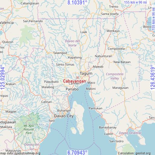
Cabayangan GPS coordinates[2]
7° 24' 25.992" North, 125° 43' 59.016" East
| Map corner | latitude | longitude |
|---|---|---|
| Upper-left | 8.10391°, | 125.02994° |
| Center: | 7.40722°, | 125.73306° |
| Lower-right: | 6.70943°, | 126.43619° |
| Map W x H: | 155.1×155.1 km | = 96.4×96.4mi |
| max Lat: | 20.78733° ⇑87.7% North |
| Cabayangan: | 7.40722° |
| min Lat: | ⇓12.3% South 4.65442° |
| min Long | Cabayangan | max Long |
| 117.04868° | 125.73306° | 126.58417° |
| W 96.1%⇐ | ⇒3.9% E |
Elevation
Elevation of Cabayangan is 5 m = 16 ft, and this is 82.9 m = 272 ft below average elevation for this country.
| Max E: |
2262 m = 7421 ft | 95.5% |
| Avg. | 87.9 m = 288 ft | |
| Cabayangan | 5 m = 16 ft | |
Min E: |
-2 m = -7 ft | 4.5% |
See also: Philippines elevation on elevation.city.
Geographical zone
Cabayangan is located in North Torrid zone (between Equator and Tropic of Cancer). Distance of Equator is 823.6 km =511.8 mi to South.| Distance of | km | miles | from Cabayangan |
|---|---|---|---|
| North Pole | 9183.5 | 5706.4 | to North |
| Arctic Circle | 6577.6 | 4087.1 | to North |
| Tropic Cancer | 1782.3 | 1107.5 | to North |
| Equator | 823.6 | 511.8 | to South |


Nearby cities:
15 places around Cabayangan: (largest is in red/bold)
• Alejal
8.5 km =5.3 mi,  252°
252°
• Anibongan
2.2 km =1.4 mi,  225°
225°
• Bincoñgan
4.9 km =3 mi,  157°
157°
• Carmen
6 km =3.7 mi,  209°
209°
• Corocotan
4.4 km =2.7 mi,  100°
100°
• Esperanza
9.4 km =5.8 mi,  356°
356°
• La Paz
10.2 km =6.3 mi,  179°
179°
• Libuganon
8.2 km =5.1 mi,  142°
142°
• Magugpo Poblacion
9.1 km =5.7 mi,  60°
60°
• Manaloal
9.2 km =5.7 mi,  240°
240°
• New Leyte
10.5 km =6.5 mi,  10°
10°
• Pagsabangan
8.4 km =5.2 mi, 12°
• Santo Niño
9.3 km =5.8 mi,  199°
199°
• Tubod
10.5 km =6.5 mi, 247°
• Tuganay
4.4 km =2.7 mi,  194°
194°
Sources, notices
• [Note1] Compared only with cities in Philippines existing in our database
• [Src1] Map data: © OpenStreetMap contributors (CC-BY-SA)
• [Src2] Other city data from geonames.org with taken over terms of usage.
• [Src3] Geographical zone / Annual Mean Temperature by Robert A. Rohde @ Wikipedia
