Hipasngo geodata
Hipasngo (Eastern Visayas) is a populated place; located in Philippines in Asia/Manila (GMT+8) time zone. With population of 2,314 people, there are 3643 cities with bigger population in this country. Compared to other cities in Philippines, 61.4% of cities are located further ↑North; 84.7% of cities are located further ←West and 85.4% of cities have higher elevation than Hipasngo. Note1
Administrative division(s):
- Level 1: Eastern Visayas
- Level 2: Province of Leyte
- Level 3: City of Baybay


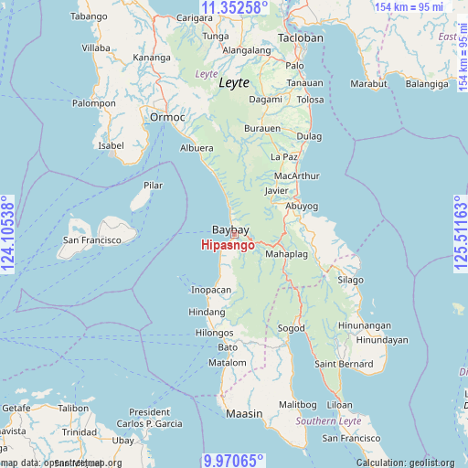
Hipasngo GPS coordinates[2]
10° 39' 44.64" North, 124° 48' 30.6" East
| Map corner | latitude | longitude |
|---|---|---|
| Upper-left | 11.35258°, | 124.10538° |
| Center: | 10.6624°, | 124.8085° |
| Lower-right: | 9.97065°, | 125.51163° |
| Map W x H: | 153.7×153.7 km | = 95.5×95.5mi |
| max Lat: | 20.78733° ⇑61.4% North |
| Hipasngo: | 10.6624° |
| min Lat: | ⇓38.6% South 4.65442° |
| min Long | Hipasngo | max Long |
| 117.04868° | 124.8085° | 126.58417° |
| W 84.7%⇐ | ⇒15.3% E |
Elevation
Elevation of Hipasngo is 8 m = 26 ft, and this is 79.9 m = 262 ft below average elevation for this country.
| Max E: |
2262 m = 7421 ft | 85.4% |
| Avg. | 87.9 m = 288 ft | |
| Hipasngo | 8 m = 26 ft | |
Min E: |
-2 m = -7 ft | 14.6% |
See also: Philippines elevation on elevation.city.
Geographical zone
Hipasngo is located in North Torrid zone (between Equator and Tropic of Cancer). Distance of Equator is 1185.5 km =736.6 mi to South.| Distance of | km | miles | from Hipasngo |
|---|---|---|---|
| North Pole | 8821.5 | 5481.4 | to North |
| Arctic Circle | 6215.6 | 3862.2 | to North |
| Tropic Cancer | 1420.4 | 882.6 | to North |
| Equator | 1185.5 | 736.6 | to South |


Nearby cities:
15 places around Hipasngo: (largest is in red/bold)
• Abuyog
24 km =14.9 mi,  66°
66°
• Balinsacayao
16.6 km =10.3 mi,  82°
82°
• Balocawehay
18.6 km =11.6 mi, 69°
• Baybay
2 km =1.2 mi,  334°
334°
• Bitanjuan
8.8 km =5.5 mi,  211°
211°
• Bugho
20.1 km =12.5 mi,  44°
44°
• Bunga
12.6 km =7.8 mi,  348°
348°
• Caridad
19.8 km =12.3 mi,  341°
341°
• Doos
23.6 km =14.7 mi,  201°
201°
• Gabas
7.6 km =4.7 mi, 349°
• Kilim
5.6 km =3.5 mi, 346°
• Mahaplag
18.2 km =11.3 mi,  110°
110°
• Palhi
1.4 km =0.9 mi,  190°
190°
• Plaridel
11.7 km =7.3 mi, 204°
• Polahongon
23 km =14.3 mi,  130°
130°
Sources, notices
• [Note1] Compared only with cities in Philippines existing in our database
• [Src1] Map data: © OpenStreetMap contributors (CC-BY-SA)
• [Src2] Other city data from geonames.org with taken over terms of usage.
• [Src3] Geographical zone / Annual Mean Temperature by Robert A. Rohde @ Wikipedia
