Cosina geodata
Cosina (Northern Mindanao) is a populated place; located in Philippines in Asia/Manila (GMT+8) time zone. With population of 3,117 people, there are 2404 cities with bigger population in this country. Compared to other cities in Philippines, 81.6% of cities are located further ↑North; 81.2% of cities are located further ←West and 97.5% of cities have lower elevation than Cosina. Note1
Administrative division(s):
- Level 1: Northern Mindanao
- Level 2: Province of Bukidnon
- Level 3: Talakag


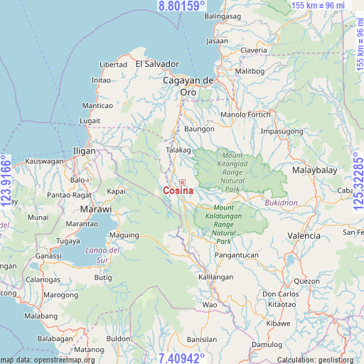
Cosina GPS coordinates[2]
8° 6' 21.996" North, 124° 37' 10.992" East
| Map corner | latitude | longitude |
|---|---|---|
| Upper-left | 8.80159°, | 123.9166° |
| Center: | 8.10611°, | 124.61972° |
| Lower-right: | 7.40942°, | 125.32285° |
| Map W x H: | 154.8×154.8 km | = 96.2×96.2mi |
| max Lat: | 20.78733° ⇑81.6% North |
| Cosina: | 8.10611° |
| min Lat: | ⇓18.4% South 4.65442° |
| min Long | Cosina | max Long |
| 117.04868° | 124.61972° | 126.58417° |
| W 81.2%⇐ | ⇒18.8% E |
Elevation
Elevation of Cosina is 702 m = 2303 ft, and this is 614.1 m = 2015 ft above average elevation for this country.
| Max E: |
2262 m = 7421 ft | 2.5% |
| Cosina | 702 m 2303 ft | |
| Avg. | 87.9 m = 288 ft | |
Min E: |
-2 m = -7 ft | 97.5% |
See also: Philippines elevation on elevation.city.
Geographical zone
Cosina is located in North Torrid zone (between Equator and Tropic of Cancer). Distance of Equator is 901.3 km =560 mi to South.| Distance of | km | miles | from Cosina |
|---|---|---|---|
| North Pole | 9105.7 | 5658 | to North |
| Arctic Circle | 6499.9 | 4038.8 | to North |
| Tropic Cancer | 1704.6 | 1059.2 | to North |
| Equator | 901.3 | 560 | to South |


Nearby cities:
15 places around Cosina: (largest is in red/bold)
• Basak
27.7 km =17.2 mi,  105°
105°
• Dagumba-an
6.1 km =3.8 mi,  328°
328°
• Dorsalanam
22.6 km =14 mi,  350°
350°
• Indulang
4.3 km =2.7 mi,  245°
245°
• Libona
28.8 km =17.9 mi,  26°
26°
• Liboran
27.8 km =17.3 mi,  6°
6°
• Lingating
25.1 km =15.6 mi,  2°
2°
• Lingion
9.2 km =5.7 mi, 353°
• Pongol
23.8 km =14.8 mi,  36°
36°
• Salimbalan
21.8 km =13.5 mi, 31°
• San Isidro
17.2 km =10.7 mi, 350°
• San Miguel
17 km =10.6 mi,  119°
119°
• Talakag
14.3 km =8.9 mi, 351°
• Ticala-an
7.9 km =4.9 mi,  179°
179°
• Tignapalan
18.2 km =11.3 mi,  344°
344°
Sources, notices
• [Note1] Compared only with cities in Philippines existing in our database
• [Src1] Map data: © OpenStreetMap contributors (CC-BY-SA)
• [Src2] Other city data from geonames.org with taken over terms of usage.
• [Src3] Geographical zone / Annual Mean Temperature by Robert A. Rohde @ Wikipedia
