Culacling geodata
Culacling (Bicol) is a populated place; located in Philippines in Asia/Manila (GMT+8) time zone. With population of 2,965 people, there are 2573 cities with bigger population in this country. Compared to other cities in Philippines, 65.3% of cities are located further ↓South; 51.1% of cities are located further ←West and 58.8% of cities have lower elevation than Culacling. Note1


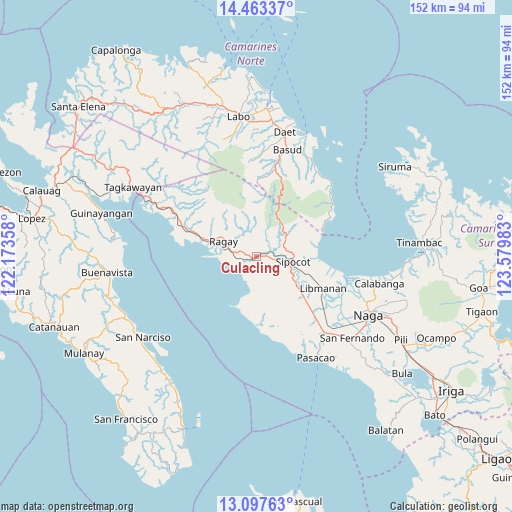
Culacling GPS coordinates[2]
13° 46' 53.4" North, 122° 52' 36.12" East
| Map corner | latitude | longitude |
|---|---|---|
| Upper-left | 14.46337°, | 122.17358° |
| Center: | 13.7815°, | 122.8767° |
| Lower-right: | 13.09763°, | 123.57983° |
| Map W x H: | 151.9×151.9 km | = 94.4×94.4mi |
| max Lat: | 20.78733° ⇑34.7% North |
| Culacling: | 13.7815° |
| min Lat: | ⇓65.3% South 4.65442° |
| min Long | Culacling | max Long |
| 117.04868° | 122.8767° | 126.58417° |
| W 51.1%⇐ | ⇒48.9% E |
Elevation
Elevation of Culacling is 32 m = 105 ft, and this is 55.9 m = 183 ft below average elevation for this country.
| Max E: |
2262 m = 7421 ft | 41.2% |
| Avg. | 87.9 m = 288 ft | |
| Culacling | 32 m = 105 ft | |
Min E: |
-2 m = -7 ft | 58.8% |
See also: Philippines elevation on elevation.city.
Geographical zone
Culacling is located in North Torrid zone (between Equator and Tropic of Cancer). Distance of this Northern Tropic circle is 1073.6 km =667.1 mi to North.| Distance of | km | miles | from Culacling |
|---|---|---|---|
| North Pole | 8474.7 | 5265.9 | to North |
| Arctic Circle | 5868.8 | 3646.7 | to North |
| Tropic Cancer | 1073.6 | 667.1 | to North |
| Equator | 1532.4 | 952.2 | to South |


Nearby cities:
15 places around Culacling: (largest is in red/bold)
• Apad
12.5 km =7.8 mi,  287°
287°
• Bao
16.3 km =10.1 mi,  197°
197°
• Barcelona
18.6 km =11.6 mi,  93°
93°
• Bolo
10.1 km =6.3 mi,  108°
108°
• Gambalidio
18 km =11.2 mi,  174°
174°
• Libmanan
22.1 km =13.7 mi,  116°
116°
• Liboro
16.6 km =10.3 mi, 286°
• Lubigan
7.9 km =4.9 mi, 123°
• Lupi Viejo
3.7 km =2.3 mi,  75°
75°
• Mambulo
20.1 km =12.5 mi, 111°
• Ragay
10 km =6.2 mi, 294°
• Sagurong
8.9 km =5.5 mi, 90°
• Sipocot
10.8 km =6.7 mi,  97°
97°
• Tara
12.2 km =7.6 mi,  71°
71°
• Tinalmud
20.8 km =12.9 mi,  179°
179°
Sources, notices
• [Note1] Compared only with cities in Philippines existing in our database
• [Src1] Map data: © OpenStreetMap contributors (CC-BY-SA)
• [Src2] Other city data from geonames.org with taken over terms of usage.
• [Src3] Geographical zone / Annual Mean Temperature by Robert A. Rohde @ Wikipedia
