Mambulo geodata
Mambulo (Bicol) is a populated place; located in Philippines in Asia/Manila (GMT+8) time zone. With population of 6,319 people, there are 989 cities with bigger population in this country. Compared to other cities in Philippines, 64.5% of cities are located further ↓South; 54.1% of cities are located further ←West and 98.8% of cities have higher elevation than Mambulo. Note1


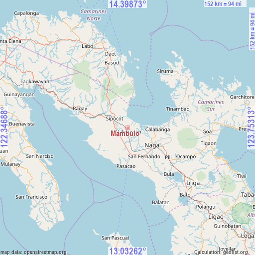
Mambulo GPS coordinates[2]
13° 43' 0.012" North, 123° 3' 0" East
| Map corner | latitude | longitude |
|---|---|---|
| Upper-left | 14.39873°, | 122.34688° |
| Center: | 13.71667°, | 123.05° |
| Lower-right: | 13.03262°, | 123.75313° |
| Map W x H: | 151.9×151.9 km | = 94.4×94.4mi |
| max Lat: | 20.78733° ⇑35.5% North |
| Mambulo: | 13.71667° |
| min Lat: | ⇓64.5% South 4.65442° |
| min Long | Mambulo | max Long |
| 117.04868° | 123.05° | 126.58417° |
| W 54.1%⇐ | ⇒45.9% E |
Elevation
Elevation of Mambulo is 2 m = 7 ft, and this is 85.9 m = 282 ft below average elevation for this country.
| Max E: |
2262 m = 7421 ft | 98.8% |
| Avg. | 87.9 m = 288 ft | |
| Mambulo | 2 m = 7 ft | |
Min E: |
-2 m = -7 ft | 1.2% |
See also: Philippines elevation on elevation.city.
Geographical zone
Mambulo is located in North Torrid zone (between Equator and Tropic of Cancer). Distance of this Northern Tropic circle is 1080.8 km =671.6 mi to North.| Distance of | km | miles | from Mambulo |
|---|---|---|---|
| North Pole | 8481.9 | 5270.4 | to North |
| Arctic Circle | 5876 | 3651.2 | to North |
| Tropic Cancer | 1080.8 | 671.6 | to North |
| Equator | 1525.2 | 947.7 | to South |


Nearby cities:
15 places around Mambulo: (largest is in red/bold)
• Barcelona
6.1 km =3.8 mi,  358°
358°
• Bolo
10 km =6.2 mi,  293°
293°
• Cabusao
7.3 km =4.5 mi,  84°
84°
• Canaman
15 km =9.3 mi,  120°
120°
• Castillo
7.4 km =4.6 mi, 77°
• Gainza
14.9 km =9.3 mi,  138°
138°
• Libmanan
2.8 km =1.7 mi,  158°
158°
• Lubigan
12.5 km =7.8 mi,  283°
283°
• Pamplona
14.3 km =8.9 mi,  166°
166°
• Pandan
4.4 km =2.7 mi,  50°
50°
• Sagurong
12.1 km =7.5 mi,  305°
305°
• San Ramon
11 km =6.8 mi,  186°
186°
• Santo Domingo
12.7 km =7.9 mi,  98°
98°
• Sipocot
9.8 km =6.1 mi, 305°
• Tara
13.2 km =8.2 mi,  327°
327°
Sources, notices
• [Note1] Compared only with cities in Philippines existing in our database
• [Src1] Map data: © OpenStreetMap contributors (CC-BY-SA)
• [Src2] Other city data from geonames.org with taken over terms of usage.
• [Src3] Geographical zone / Annual Mean Temperature by Robert A. Rohde @ Wikipedia
