Tinalmud geodata
Tinalmud (Bicol) is a populated place; located in Philippines in Asia/Manila (GMT+8) time zone. With population of 2,217 people, there are 3854 cities with bigger population in this country. Compared to other cities in Philippines, 63.1% of cities are located further ↓South; 51.2% of cities are located further ←West and 80.7% of cities have higher elevation than Tinalmud. Note1


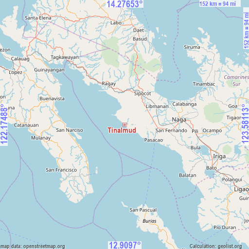
Tinalmud GPS coordinates[2]
13° 35' 38.76" North, 122° 52' 40.8" East
| Map corner | latitude | longitude |
|---|---|---|
| Upper-left | 14.27653°, | 122.17488° |
| Center: | 13.5941°, | 122.878° |
| Lower-right: | 12.9097°, | 123.58113° |
| Map W x H: | 152×152 km | = 94.4×94.4mi |
| max Lat: | 20.78733° ⇑36.9% North |
| Tinalmud: | 13.5941° |
| min Lat: | ⇓63.1% South 4.65442° |
| min Long | Tinalmud | max Long |
| 117.04868° | 122.878° | 126.58417° |
| W 51.2%⇐ | ⇒48.8% E |
Elevation
Elevation of Tinalmud is 9 m = 30 ft, and this is 78.9 m = 259 ft below average elevation for this country.
| Max E: |
2262 m = 7421 ft | 80.7% |
| Avg. | 87.9 m = 288 ft | |
| Tinalmud | 9 m = 30 ft | |
Min E: |
-2 m = -7 ft | 19.3% |
See also: Philippines elevation on elevation.city.
Geographical zone
Tinalmud is located in North Torrid zone (between Equator and Tropic of Cancer). Distance of this Northern Tropic circle is 1094.4 km =680 mi to North.| Distance of | km | miles | from Tinalmud |
|---|---|---|---|
| North Pole | 8495.5 | 5278.9 | to North |
| Arctic Circle | 5889.7 | 3659.7 | to North |
| Tropic Cancer | 1094.4 | 680 | to North |
| Equator | 1511.5 | 939.2 | to South |


Nearby cities:
15 places around Tinalmud: (largest is in red/bold)
• Bahay
18.5 km =11.5 mi,  107°
107°
• Bao
7.3 km =4.5 mi,  316°
316°
• Bolo
20.1 km =12.5 mi,  28°
28°
• Caranan
17.2 km =10.7 mi,  120°
120°
• Culacling
20.8 km =12.9 mi,  359°
359°
• Dalupaon
8.7 km =5.4 mi, 122°
• Gambalidio
3.3 km =2.1 mi, 26°
• Lubigan
17.6 km =10.9 mi,  21°
21°
• Lupi Viejo
22 km =13.7 mi,  8°
8°
• Odicon
20.8 km =12.9 mi, 110°
• Pasacao
20 km =12.4 mi, 117°
• Quitang
19.5 km =12.1 mi,  104°
104°
• San Ramon
17.5 km =10.9 mi,  81°
81°
• San Vicente
19.1 km =11.9 mi, 96°
• Tambo
17.8 km =11.1 mi, 107°
Sources, notices
• [Note1] Compared only with cities in Philippines existing in our database
• [Src1] Map data: © OpenStreetMap contributors (CC-BY-SA)
• [Src2] Other city data from geonames.org with taken over terms of usage.
• [Src3] Geographical zone / Annual Mean Temperature by Robert A. Rohde @ Wikipedia
