Casala-an geodata
Casala-an (Central Visayas) is a populated place; located in Philippines in Asia/Manila (GMT+8) time zone. With population of 2,875 people, there are 2669 cities with bigger population in this country. Compared to other cities in Philippines, 75.1% of cities are located further ↑North; 54.1% of cities are located further ←West and 86.4% of cities have lower elevation than Casala-an. Note1
Administrative division(s):
- Level 1: Central Visayas
- Level 2: Province of Negros Oriental
- Level 3: Siaton


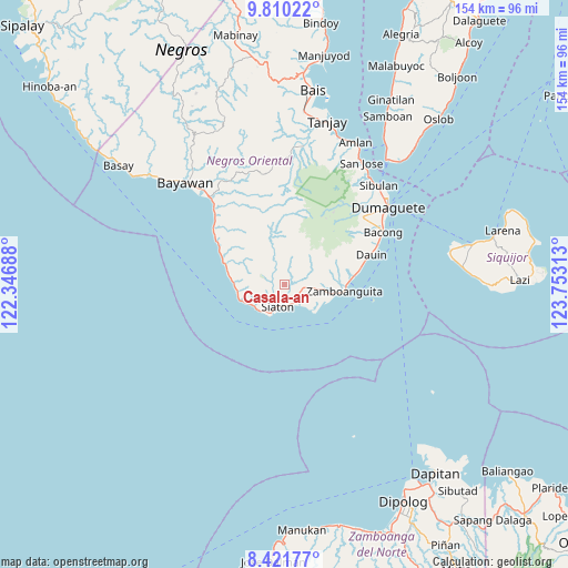
Casala-an GPS coordinates[2]
9° 7' 0.012" North, 123° 3' 0" East
| Map corner | latitude | longitude |
|---|---|---|
| Upper-left | 9.81022°, | 122.34688° |
| Center: | 9.11667°, | 123.05° |
| Lower-right: | 8.42177°, | 123.75313° |
| Map W x H: | 154.4×154.4 km | = 95.9×95.9mi |
| max Lat: | 20.78733° ⇑75.1% North |
| Casala-an: | 9.11667° |
| min Lat: | ⇓24.9% South 4.65442° |
| min Long | Casala-an | max Long |
| 117.04868° | 123.05° | 126.58417° |
| W 54.1%⇐ | ⇒45.9% E |
Elevation
Elevation of Casala-an is 156 m = 512 ft, and this is 68.1 m = 223 ft above average elevation for this country.
| Max E: |
2262 m = 7421 ft | 13.6% |
| Casala-an | 156 m 512 ft | |
| Avg. | 87.9 m = 288 ft | |
Min E: |
-2 m = -7 ft | 86.4% |
See also: Philippines elevation on elevation.city.
Geographical zone
Casala-an is located in North Torrid zone (between Equator and Tropic of Cancer). Distance of Equator is 1013.7 km =629.9 mi to South.| Distance of | km | miles | from Casala-an |
|---|---|---|---|
| North Pole | 8993.4 | 5588.2 | to North |
| Arctic Circle | 6387.5 | 3969 | to North |
| Tropic Cancer | 1592.2 | 989.3 | to North |
| Equator | 1013.7 | 629.9 | to South |


Nearby cities:
15 places around Casala-an: (largest is in red/bold)
• Apoya
19.6 km =12.2 mi,  306°
306°
• Bonawon
14.5 km =9 mi,  277°
277°
• Cabangahan
12.1 km =7.5 mi,  249°
249°
• Canauay
5.7 km =3.5 mi,  177°
177°
• Caticugan
5.8 km =3.6 mi, 251°
• Maayong Tubig
22.3 km =13.9 mi,  75°
75°
• Maloh
9.8 km =6.1 mi,  226°
226°
• Malway
18.8 km =11.7 mi, 84°
• Manalongon
21.4 km =13.3 mi,  302°
302°
• Mantiquil
5.6 km =3.5 mi,  0°
0°
• Mayabon
13.8 km =8.6 mi,  99°
99°
• Nagbalaye
24.1 km =15 mi, 307°
• Sandolot
3.6 km =2.2 mi, 248°
• Siaton
6 km =3.7 mi,  197°
197°
• Zamboanguita
16.5 km =10.3 mi, 95°
Sources, notices
• [Note1] Compared only with cities in Philippines existing in our database
• [Src1] Map data: © OpenStreetMap contributors (CC-BY-SA)
• [Src2] Other city data from geonames.org with taken over terms of usage.
• [Src3] Geographical zone / Annual Mean Temperature by Robert A. Rohde @ Wikipedia
